ST. LOUIS AND THE BEGINNING
Contents
SO BEGINS THE RISE OF CHARLES GRATIOT
CHARLES GRATIOT’S COUNTRY HOME
WILLIAM SUBLETTE’S FIRST HOMESTEAD
Figures
Figure 1. St. Louis Mounds Map
Figure 2. The Big Earthen Mound
Figure 3. Choosing the Post Location
Figure 6. Map of the Gratiot League Square
Figure 8. Gratiot Childhood Home
Figure 9. Henry Gratiot's Country Home
Figure 10. Sublett's First Home
(From the book “St. Louis Lost”)
Among the changes wrought in the name of progress was the gradual but systematic removal of the 27 earthen ritual, and burial mounds that were part of the St .Louis landscape when Chouteau and Laclede arrived.
Nineteenth century archaeologists found that there was a chain of mounds running the length of the Mississippi and its tributaries. The builders of these mounds were a part of a sophisticated society that maintained a system of travel and communication that extended as far as Mexico.
Fortunately, a Major Long made a drawing of the St. Louis mound locations near the river before there was much building in those areas.
It shows a circle of small mounds near the center of the future town .and a large square mound to the southeast. A few mounds west of the city, and a very large mound to the north.
Figure 1. St. Louis Mounds Map
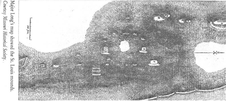
This map made from his drawing was included in the Smithsonian report for 1861. While Long’s drawing was not to scale, it does show that the mounds were man-made and not formations caused by the ebb and flow of the Mississippi River.
The St. Louis mounds were similar to the large mound at Cahokia built by the Mississippian Indians. Some early residents could not believe that “Primitives” could have created them”.
They held to the belief that the Irish and the Welsh found America before Columbus. They speculated the mounds were built by Celtic predecessors. Some tried to strike up conversations with the Native Americans in old welsh to prove their discovery theory, but they were unsuccessful.
St. Louis gained its nickname “Mound City” in the late 18th century from river travelers who used the two largest mounds as landmarks. The largest, LaGrange De Terre (Earthen Barn), as it was called by the Creoles, was located at what is now Broadway and Howard. The water was low, exposing at the base of the bluff, a shelf of rock that extended a hundred feet or more into the river. They drew the boat onto the shelf and climbed to the bluff’s broad top. Between the bank and the crest of a ridge some hundred feet away was a forest of giant trees.
Beyond the ridge to the west was LaGrand Prairie, seared from the winter burning by the Indians, but dotted with thickets of wild plum, crab apple, and scrubby oak. Here and there on the prairie were small spring fed streams, and large sink holes formed by drainage into the caverns that undermined the area.
To the south, a wide valley cut by a stream called LaPetite Riviere (The Little River). Then another bluff, (and beyond it a second stream), LaRiviere DesPeres” (The River of the Fathers). Laclede must have realized these bluffs were the key to the upper Mississippi Valley.
Around him was evidence that an earlier race had recognized that too. On the nearby bluffs were some two dozen prehistoric mounds, dominated by an immense mound which the creoles would soon name “The Earthen Barn”. This was located at what is now Broadway and Howard. Across the river was the largest group of mounds on the continent. This would be called “Cahokia Mounds”. More on this later.
After marking some trees, they returned to Fort DesChartres for the winter.
Located on land bounded by Broadway, Second Street, Mound Street, and Brooklyn Street. As St. Louis grew, the mounds were gradually destroyed to accommodate buildings and streets.
In 1842, a British traveler, James S. Buckingham observed, “The indifference manifested by almost all classes of Americans towards these antiquities of their own country, renders it almost certain that in a few years, the great number of them will disappear”.
Early St. Louisans did not view the mounds as important antiquities. In the very early days, residents would climb the larger ones to view the far away fires that had been set to burn off prairie grass.
A mound near Ashby St. was pressed into service in 1838 as the city’s first reservoir. And in 1844, an entrepreneur leveled part of the top of LaGrange De Terre and built a small tavern. Although the views were grand, the tavern soon failed, and the building was soon razed.
Figure 2. The Big Earthen Mound
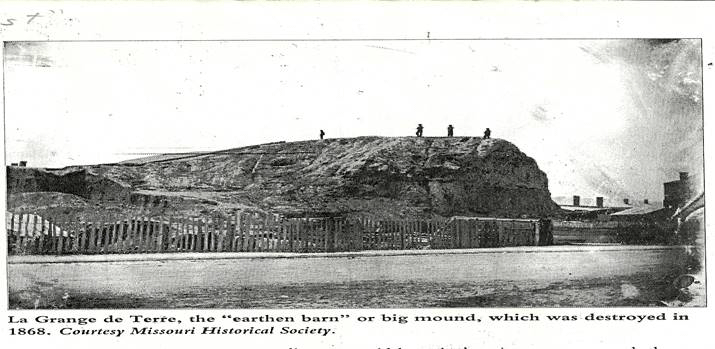
By 1855, streets cut through both the north and south ends of LaGrange De Terre, and in 1866, Archbishop Peter Kenrick sold the major portion of the site to a group of New York investors for $18,000. The remainder of the mound site was sold to a blacksmith for $12,000. Destruction began in earnest in 1868 with workers carrying away cartloads of the mound, including bones and artifacts which were used as fill dirt in a construction project of the Northern Missouri Railroad.
One newspaper writer noted sadly, that “To all intents and purposes, the mound is gone. What should have been bought by the city and preserved inviolate, will soon be known only in local tradition”.
Other mounds were located west of the city, and they too were leveled. One, located near Kingshighway and Martin Luther Drive, was known as “Cote Brilliante” (Shining Hill). It was destroyed in 1877, in conjunction with construction of the Christian Brothers College.
Two smaller mounds, located in Forest Park, were destroyed during construction for the Louisiana Purchase Exposition. A mine was left to show fair goers an operating mine.
From the book- “St. Louis Lost” By Mary Bartley
1718 – New Orleans founded.
1722 – New Orleans became the capital of Louisiana
1729 – Pierre De Laclede born (Nov.22).
1754 – Outbreak of the Seven Years war (Also known as the French and Indian War). Actually between France and England
1755 – Pierre De Laclede landed in New Orleans – Age-26. Sometime after his arrival, Laclede met Madam Chouteau.
She was the estranged wife of Inn-Tavern keeper Rene August Chouteau, who was an embittered failure, and after deserting his wife and young son, Auguste, had gone back to France.
1749 – August Chouteau was born September 7th as the “legitimate Son” of Rene’ and Marie, his wife. Sometime after the father departed, four children were born (between 1758 and 1764), they were the offspring of Laclede and Marie.
The baptismal records were worded differently;”They were born of the legitimate marriage of Rene’ and Marie”.
Divorce was prohibited both by the Church and State, but permanent separations were common since neither party had the legal right to remarry during the other’s lifetime.
1759 – England captured French Canada and the British fur traders started moving south.
1762 – The French lost the war and had relinquished Canada and the Illinois country east of the Mississippi.
1763 – The Governor of Louisiana Territory, Jean Jacques D’Abbadie offered Antoine Maxent a six year fur trading monopoly with Indians of Missouri, west of the Mississippi, north to the DesMoins River. Laclede agreed to direct the venture in the field. Auguste Chouteau, at 14 years, was his clerk.
1763 - August 3, 1763, Laclede’s party left New Orleans using a shallow draft boat (raft) against the current. By autumn of 1763, Laclede’s crew came up the river to Cape Girardeau and the gray limestone bluffs Cape DeLacroix that marked the beginning of the upper river. Indian mounds were in this area.
Miles beyond, was the “Grand Tower”. (A massive column of stone rising midstream). Kaskaskia lay ahead on the east bank. A Fort on the hill above guarded the peaceful village. On the west bank, came LaRiviere DesSalines, and finally, St. Genevieve, a village established a generation before.
There was no room to store their goods, so they were invited to store them at Fort DeChartres, a few miles upstream, (A stone citadel on the east bank of the river). They arrived at the fort in early November (700 miles in three months).
After setting up winter quarters, Laclede and Auguste set out upstream in December to select a location for his post. Laclede had planned for a location near the mouth of the Missouri River, but it was too swampy. Twenty miles downstream, the river swirled against a bluff that rose thirty to forty feet above the water on the west bank.
Figure 2. Choosing the Post Location
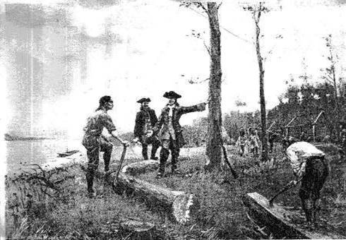
The water was low, exposing at the base of the bluff, a shelf of rock that extended a hundred feet or more into the river. They drew the boat onto the shelf and climbed to the bluff’s broad top. Between the bank and the crest of a ridge some hundred feet away was a forest of giant trees.
Beyond the ridge to the west was LaGrand Prairie, seared from the winter burning by the Indians, but dotted with thickets of wild plum, crab apple, and scrubby oak. Here and there on the prairie were small spring fed streams, and large sink holes formed by drainage into the caverns that undermined the area.
To the south, a wide valley cut by a stream called LaPetite Riviere (The Little River). Then another bluff, “and beyond it a second stream,” LaRiviere DesPeres” (The River of the Fathers). Laclede must have realized these bluffs were the key to the upper Mississippi Valley.
Around him was evidence that an earlier race had recognized that too. On the nearby bluffs were some two dozen prehistoric mounds, dominated by an immense mound which the creoles would soon name “The Earthen Barn”. This was located at what is now Broadway and Howard. Across the river was the largest group of mounds on the continent. This would be called “Cahokia Mounds”. More on this later.
After marking some trees, they returned to Fort DesChartres for the winter.
1764 – In February August was sent with thirty men to clear and mark off the plan for the settlement. They began construction while Laclede recruited workers, and bought supplies and tools in Kaskaskia, Cahokia, and other Creole settlements. They had to hurry before the British took over the east side of the river.
As summer wore on, word came of the 1763 treaty of Paris that ended the French and Indian War. The east side of the river did go to British rule. Later in the year, St. Louis also received the surprising news that two years earlier, the French King had made a secret treaty transferring New Orleans and the Louisiana Territory west of the Mississippi to his cousin, the King of Spain. In spite of this, it was easy to induce French settlers to move to the west side of the river. They weren’t too comfortable with the British on the east.
The pain must have been eased with the Spanish Land Grants. Also this must have helped to have a buffer zone for them and their Indian friends, the Osage Indians. It would slow the advance of the British.
1764 – By May, shortly after the baptism of her last child, Madame Chouteau left for St. Louis with her children. They arrived late in August, just as the village began to take shape.
Her husband Rene, was back in New Orleans in 1767, but did nothing until 1774. He tried to force her to return to New Orleans. After two years of delays, he died in 1776.
Laclede took care of the family to a point. (Living quarters, and care). There is a hint he lived in separate quarters. Laclede never married her, although, some think there was a Civil wedding. He never adopted the children, although the last four are thought to be his.
By the end of 1764, with a population of forty families, Laclede’s Village had become a reality. He set Madame Chouteau up with a house in 1768. This was a residence lot with a stone building, a farm lot, two African, and two Indian slaves. She was to have the use of this property during her lifetime, with the right to sell and purchase other property, which she did very well.
According to the deed, these gifts were made in consideration of the services performed by Auguste, and as a demonstration of Laclede’s affection for all of the children. According to family records, Laclede and Marie were married in a civil ceremony, which if true, must have been little more than a symbolic act. (From Lion of the Valley). Still it’s reasonable to think they married, after the death of Rene
She later became known as “The Mother of St. Louis”. This book “The Royal Family of The Wilderness”, calls her the “Queen”. The family grew and became the dominant force in the city. The Indians even called St. Louis “Chouteau Town”.
Figure 4. Charles Gratiot
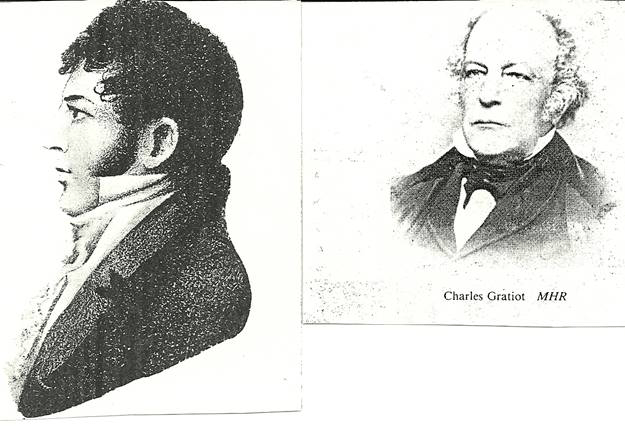
Charles Gratiot was born in 1752 in Lausanne Switzerland. His father, David Henri Gratiot, and his mother, Marie (Bernard) Gratiot, were French Huguenots, who had fled Normandy France at the time of the revocation of the Edict of Nantes in 1685. After receiving his early education in Lausanne Switzerland, he was sent to an uncle in London to learn the merchantile trade. He later joined another uncle in the fur trade in Montreal.
In 1774, he was sent to Illinois Country on a trading expedition and determined to settle there. In 1777, he severed his connection with his uncle and established himself at Cahokia in Illinois.
Before coming to St. Louis, Charles Gratiot had secured support of the French for George Rogers Clark, during his attack on Kaskaskia. He also helped finance the expedition. This was during the French and Indian war. The English, angered by this, arranged for Gratiot to be kidnapped.
Ottawa Indian Chief, “Pontiac”, rescued him a few hours journey from the British Fort, and saved him from being hanged.
Gratiot had not moved to the St. Louis side yet.
1769 – Chief Pontiac was murdered at Cahokia. This led to a bloody war between the Ottawa and the Illinois tribes. The Illinois’ were practically wiped out
1778 – Pierre Laclede died.
1780 – British forces began assembling along the upper Mississippi with the Sioux Indians, and Canadian trappers and traders.
Figure 5. Gratiot Struggles
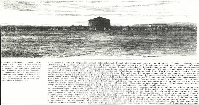
Charles Gratiot, then a Cahokia merchant innocently (?) provided them with needed arms, ammunition, and supplies. He had gotten both American and Spanish permission to send a boatload of Indian trade goods to Prairie D Chien. The British, directed by the brother of one of Gratiot’s former Canadian partners, seized the shipment.
This neatly timed episode caused Gratiot to be charged with treason. But his accusers could not produce the evidence of it. Probably, no one knew what the British were planning, although Pierre Prevost had written from the Salt River (Ralls County Mo.), that the British Agents were visiting the tribes along the upper Mississippi, inciting them to attack the American and Spanish Villages. This is when Fort San Carlos was built.
This story may be the reason the Chouteaus didn’t trust Charles Gratiot. (I picked up this idea somewhere);
1781 – Charles Gratiot moves to St. Louis and marries Madame Chouteau’s youngest daughter “Victorie”.
He moved to St. Louis, and became a Spanish subject in order to be able to trade on both sides of the river. He was interested in the cause of the American Revolution. Besides helping finance George Rogers Clark, he was also a major contributor to the Lewis and Clark expedition to the west.
From “The Royal Family of the Wilderness”
Charles Gratiot was well educated, handsome and loquacious. A dreamer with not much patience to carry the dream. I have wondered why he isn’t mentioned much in St. Louis history, (not including my early lack of interest in history or the world around me). He evidently was noted for his grand schemes, which may be the reason for the idea that the Chouteau’s were wary of him.
Charles learned the merchantile business from an uncle in London, who he didn’t like, and got homesick. At seventeen, he was sent to Montreal, where another uncle taught him the international operations of the fur trade. In 1777 this uncle also made him his agent in Illinois country. He did well the first season, but the following year a partner’s extravagant spending caused the venture to fail. His uncle didn’t listen, “Like talking to a bronze statue”.
Gratiot then set himself up as a merchant in Cahokia. Business was good until George Rogers Clark conquered the region for Virginia in 1778, and rumors spread of a planned American invasion of Canada.
(This ties in with my above story of the trouble with England).
Gratiot worried about getting his peltries to England. Less than a year later, he found it impossible to carry on business in the American zone, so he moved to St. Louis in 1781 with assets that had dwindled to $2500. In June, he married Victoire Chouteau.
After the American Revolution, he traveled to Virginia and spent months trying to collect old bills. He finally took what he could get, 10 slaves, some hogshead of tobacco, and the balance of $18,000 in Kentucky Land warrants.
During his return trip to St. Louis, he met a stranger at a Louisville tavern wearing a cocked hat. He was called “The Major”, who offered to locate Gratiot’s land claims for him. Gratiot gave him the warrants and departed without getting a receipt, or asking the man’s name. Gratiot, ever naïve thought it odd that he never heard from him again.
For seven years, Gratiot stuck to his fur trade, then growing restless and eager for wealth, he conceived a grand scheme of establishing business connections in Europe.
1791 – Charles Gratiot sailed from New Orleans for Bordeaux, France, visited his family in Lausanne, and stopped in London, where he met the important fur merchant John H. Schneider who talked him into a ruiness business partnership with one of his protégées.
During a second visit to London in 1793, Gratiot again became an easy victim of the fast talking Schneider, who this time promised to help him establish a branch house in St.Petersburg or Ostend.
Gratiot explained this plan in a letter to the Chouteaus, saying that in Europe “One could make his way without being exposed to those sudden reverses frequent in America”.
He decided to stay in Europe and ordered his St. Louis property sold. A few months later though, Gratiot realized “His own foolish credulity” and hastened back to St. Louis. Schneiders letters pursued him, but Gratiot replied that he was cured of his follies. With his farm, coal mine, salt spring, and the little business that remained, he could do very well. A sister-in-law gave him a loan, and his greatest ambition now was “To be able to merit the esteem of good people”.
From the books:
“Lion of the Valley” – Pg 53-55 Charles Gratiot
“St. Louis” An Informal History of the City and Its People - By Charles Van Ravensway
1804 – The transfer of Louisiana disclosed a whole new world beyond the Alleghenies. So the exodus to the west began. A flood of migration of all kinds of people. With them came the “Great Revival”, crossing the Mississippi like crossing the River Jordan into the Promised Land.
Then Creoles lamented the coming of the drunken, violent Americans, and felt the newcomers were swallowing them up. When the Americans took over Louisiana in 1804, Gratiot was among the half dozen most powerful men in the district. Until his death in 1817, Charles Gratiot and August Chouteau were office holders and major figures in the area’s dominant political faction.
At the time of the transfer of Upper Louisiana to the United States, Gratiot was one of the few Frenchmen in St. Louis to approve. He signed the transfer papers as one of the four witnesses, and part of the transfer ceremonies took place at his house on the corner of Main and Chestnut Streets.
The treaty was signed March 10, 1804 on the portico of the Gratiot home with Charles as the Interpreter. Seventeen year old Charles Jr witnessed the ceremony.
On March 26, 1804 the Land Act separated Louisiana into two territories at the Thirty Third Parallel.
The Southern: “Territory of Orleans”.
The Northern: The upper, former Spanish Illinois, and Arkansas were lumped together in a new “District of Louisiana”, with St. Louis as one of its Sub-Districts.
They were to be governed by officers of the “Territory of Indiana”. St. Louisans were offended to think they were too incompetent to manage their own affairs. As Charles put it: ”They had been calumniated in Congress”, and no one was there to speak for them.
At the same time, St. Louisans learned of two other troubles:
1) That Congress planned to relocate some eastern Indian tribes to the western side of the Mississippi.
2) The Spanish Land Grants issued after 1800 were to be voided. The easterners didn’t trust the French Royalty, who some called “The Junto”. One book said Gratiot was a leader. These points were later argued and defeated.
When the town incorporated in 1809, Charles was elected a trustee of St. Louis and filled other public offices. But he directed his chief efforts toward conserving his considerable land holdings. Note: I read somewhere, he served as Recorder of Deeds.
During these years, he also became Indebted to John Jacob Astor of New York. Astor’s ambition to control the American Fur Trade was thwarted by the independence of the St. Louis traders.
Astor was most lenient about Gratiot’s debt, preferring to use him as informant about his friends and relatives, Astor’s fur trade competitors. It is not clear whether the St. Louis merchants caught on or if Gratiot despised his own frequent and informative letters to New York, but with old age he became nervous and jumpy, obsessed with his property. This may be an old wives tale, with so much speculation. Maybe not. (Peter Chouteau hooked up with Astor later on, and worked against Sublette).
Charles Gratiot died of a paralytic stroke on 21, April 1817 at age of 65. This became a triple hit to St. Louis that year. Edward Hempstead, only 38 collapsed and died as the result of a fall from a horse a few weeks earlier. Also Thomas Hart Benton killed Charles Lucas in a duel on Bloody Island. (Two duels, where Lucas was first shot through the throat, then secondly through the heart). Gratiot and Hempstead were two favorites, and sorely missed. (from “Lion of the Valley by Neal Prim). Victoire survived Charles by eight years and died at the same age of 65. They are buried in Calvary Cemetery. Charles Gratiot died leaving his widow and family rich in Real Estate.
The different shadows of Gratiot’s background, muddy up the waters. A money maker, a Patriot, a Frenchman, a friend of the English, the Spanish, the World and the Rich. One of St. Louis’ early, large property owners. He did leave his mark.
This ties in with the above story of “The Informal History of the City and its People)
Now, back in 1804 the Creoles thought they had an ally in Congressman Jean Baptiste Charles Lucas since he was French, but were shocked when in February, he told congress that Creoles along the Mississippi were not ready for full citizenship. And that they had no experience with democratic government. He recalled that many wept during the transfer ceremonies, and recommended attaching Upper Louisiana to the territory of Indiana, which they did.
Early in April of 1804, August Chouteau and other St. Louis leaders (mostly Creoles) called a meeting with representatives from all over the new district. Some Americans from the St. Genevieve area charged the Creole Clique with acting illegally. Still the Convention met in St. Louis September1804.
For St. Louis: August Chouteau, Charles Gratiot, Pierre Provenchere, Louis LaBeaume, Bernard Pratt, Charles Sanquinet, and American James Rankin.
For the American Opposition: Moses Austin, Rufus Easton, a Frenchman Michel Amoureaux of St. Genevieve.
After an oath of Allegiance in both French and English, Gratiot the Chairman pointed out that the meeting was the first Representative Assembly to be held in the Territory. “Wish to God” Gratiot added fervently, “our first communication with congress, instead of being an application for redress, would have been an expression of thanks”. The meeting lasted two weeks with a Petition to Congress.
On October 12, 1804, Indiana Territorial Governor William Henry Harrison arrived in St. Louis to establish the new District Government. On Harrison’s recommendation, the President appointed Col. Samuel Hammond of Georgia as the new Commandant of the St. Louis sub-district, and members of the Creole Elite to its Courts. Charles Gratiot as the Presiding Judge of the Court of Common Plea’s and Quarter Sessions. Auguste Chouteau, Jacques Claymorgan, David Delaunay, and James Mackay were named Associate Judges.
Figure 6. Map of the Gratiot League Square
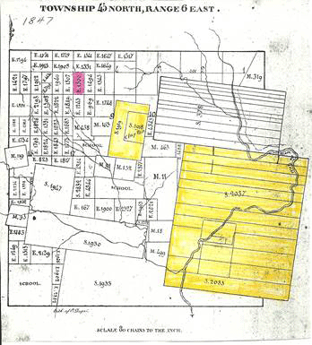
So named for Charles Gratiot Sr. who received this land grant first in 1785 by Cruzat, and was finally confirmed in 1798 by Spanish Gov. Manuel Gayose DeLemos at New Orleans. This being 3 Square Miles, (5712 Acres). The boundaries being Kingshighway, Big Bend, and ¾ of Forest Park (on a line with approximately Forest Park Blvd.) to Pernod in the south. (Survey 2037).
The prominent land being the Valley of the River Des Peres. This was almost too late, for the new U.S. Government in 1804 wanted to invalidate all Land Grants after 1800. This effort did not pass, but the government would not give a blanket OK to all land grants. It took until 1809 for Gratiot to get his grant approved. They thought there were too many quick deals before the deadline.
Charles named the road along the eastern edge of his property “The Kings Highway” in honor of the King of France. From the beginning, he made extensive improvements in his farm: A house, orchard, garden, a mine of stone coal, a saline, and mill site. This was his “Country Home”
Not long after the acquisition of his League Square, Charles began to sell parts of his immense tract. Soon a good number of large sized farms and estates appeared (can’t find who). It was included in the grant agreement that the land was to be developed and productive. Most of his land was virtually untouched until Sublette’s time in the 1830’s, and the beginning of Clay Mining.
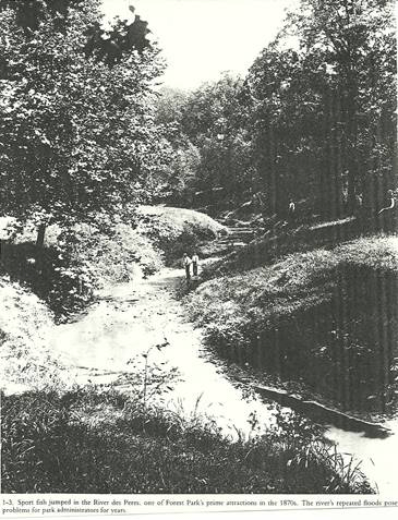
Gratiot’s League Square was a beautiful stretch of land with the little River DesPeres meandering through the valley. The river ran from north St. Louis County, through the park and into the valley just west of Kingshighway to what is now the city limits, then south to the Mississippi at Carondelet.
“The valley along the River DesPeres had the usual tree growth that goes with streams. The hills on each side were covered with trees. A group of Lordly Oaks shaded a clump of Papaws. Here and there leaned over the stream, a Capple-Bark Sycamore. Again a solitary, Gigantic Cottonwood stood. There were thickets of Hazel, stretches of wild apple and on the uplands one struggles through the briars of Wild Blackberry”. (From Shaw’s Garden Bulletin).
Figure 7. River des Peres
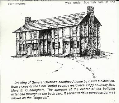
I have not been able to pinpoint the exact location, I do have a drawing from a copy of the 1790 Gratiot Country Home. Why an article said it was the childhood home Charles Jr. grew up, I don’t know. It may have been during the days of Charles Sr.’s traveling to Europe. They had a beautiful home on Main St. downtown.
The country home had an aperture at the center of the building which extended through to the back yard. This was known as the Dog Walk.
Figure 8. Gratiot Childhood Home
As of this year (2004) the location still has not been proved. After reviewing the two stories below, and a couple of old maps, I’m pretty sure, although that’s not historical. A look at The Pictoral Map of 1876, and an 1890 Plat Map could help verify the spot as being on Northrup just east of Macklind. See the descriptions below.
From “The First American Frontier” PG. 399
The first house built on the Gratiot League Square, (First Hint), and one of the earliest near the Village, (St. Louis), where he lived for a number of years after his marriage in 1813.
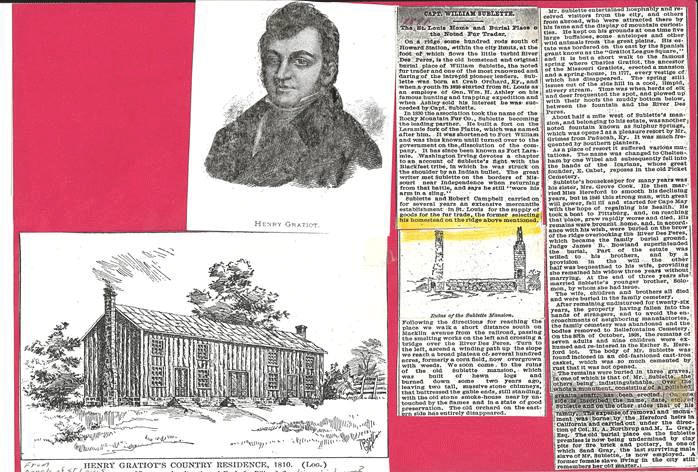
Figure 9. Henry Gratiot's Country Home
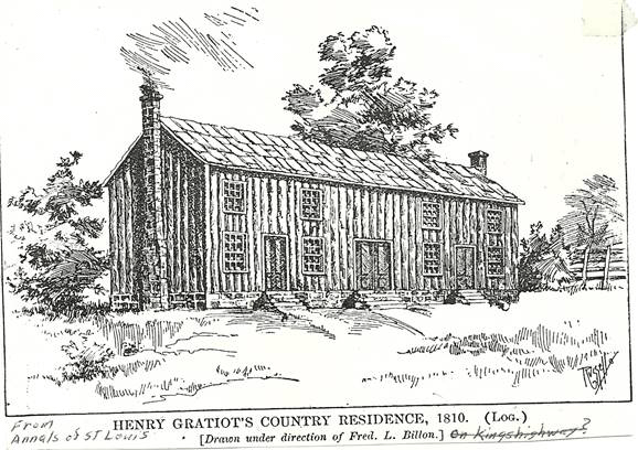
A weather boarded log house one and a half stories high, fifty feet long, by 60 feet deep on a stone foundation about four feet high with a stone chimney at each end.
Three doors on the east front, one to each room, with a shed over the steps to each, in place of the gallery which originally extended along the whole front of fifty feet. The real gallery still remains in a dilapidated condition. (This sounds like he rehabbed the original house. The picture of it looks identical to Charles’ Country Home, with the changes.)
Each of these homes are two story log homes. Charles’ doesn’t show it, but Henry’s does. Typically French Style with the logs upright, really a story and a half high, four windows on each side of a middle Dog Walk, which Henry closed in, and a chimney on each end.
So there you have it, my theory of the old original homestead. It’s a stretch, but the best I can come up with.
The 1891 description describes it this way: It stands on high ground overlooking the countryside in each direction, about three eights of a mile west of Kingshighway which is the east line of Gratiot League Square, and one-hundred-fifty yards north of Pattison Ave. which leads to it.
A deep well of water stands about fifty yards northeast of the house. A part of the old stone foundation of Gratiot’s old Mill are still to be seen (1881). A short distance north of the house, on the slope of the hill which descends to the River Des Peres, and the ruins of the old spring house, in a hollow about two-hundred yards east. Also a number of old dead apple trees remain east of the house. The 1876 Pictorial Map shows the orchard. The builder of this house (Henry) died at Barnums Hotel, Baltimore in April 1835.
WILLIAM SUBLETTE’S FIRST HOMESTEAD
Figure 10. Walking Tour #1
THIS WAS FOUND IN A SARAH B. HULL SCRAPBOOK (1891)
This is a newspaper article describing William Sublette’s Mansion. Actually this is still the old Gratiot Country Home.
First built by Charles Gratiot, improved by Henry Gratiot then bought by William Sublette. The Sublette Mansion comes later. A drawing in the article shows the ruins of the building with only the chimneys and foundation still standing. This is my speculation, can’t prove it yet.
The article states: “On a ridge some hundred rods south of Howard Station, within the City Limits at the foot of which flows the turbid Rive Des Peres, is the old homestead and original burial place of William Sublette, the noted Fur Trader and one of the most renowned and daring of the Intrepid Pioneer Leaders”. Sublette selected his homestead on the ridge above mentioned.
It continues: “Following the directions for reaching the place, we walk a short distance south on Macklind from the railroad, passing the Smelting Works on the left, and crossing a bridge over the River Des Peres, turn to the left, ascend a winding path up the slope, we reach a broad plateau of several hundred acres, formerly a corn field now overgrown with weeds. We soon come to the ruins of the old Sublette Mansion, which was built of hewn logs, and burned down some two years ago, leaving two tall massive stone chimneys that buttressed the gable ends still standing, with the old stone smoke house nearby untouched by the flames, and in a state of good preservation. The old orchard on the eastern side has entirely disappeared”. (In the fire two years before –1889).
Figure 11. My Walking Tour #2
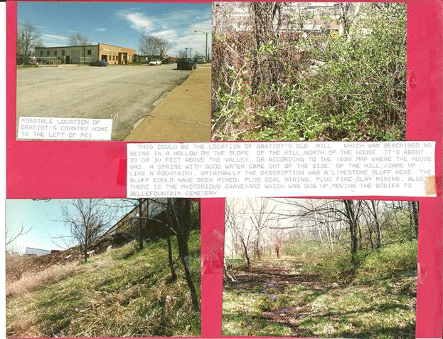
Putting these stories together the Charles Gratiot-1790, Henry Gratiot-1810, and William Sublette-1831 homes to me were one and the same. At approximately the location described, there is a ridge on the south side of the Frisco Tracks, and overlooking the valley is an Auto Body Shop (Southtown Auto Upholstery), which is located at 5301 Northrup. With the P.C.I. Filtration Services at 5323 Northrup.
In back of P.C.I. there is a ridge, just like an old dump site. I could see about 20 or 30 Feet below, a flat area behind a small company named “John Boyle and Company” at 1630 Macklind. After receiving permission I looked around back and found a swampy area which could be the old spring that came out of the side of the hill. Or maybe just drainage from the hill. There was a sewer grate, but it sat too high to drain the lot. I walked around through the weeds on this hillside and found the usual dump material, plus what looked like cinders, just like the dump that used to be on Plateau, up the street from my house on Brock Street.
I took a few pictures, and for now, I choose this spot as either “Gratiot’s old mill on the slope of the hill which descends to the river” or “The old spring house in a hollow about 200 yards east”.
Figure 12. Walking Tour #3
The house was said to have been “Facing east, but with a good view of the whole valley. I will stay with this as the old Gratiot Country Home until someone proves me wrong.
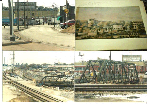
Next (walking tour #2), are a set of pictures showing an uncanny possibility they built that motel just about where the Sublette Mansion was up there on that hill. It may not be perfect, but the painting shows in the bottom right corner, the Sulphur Springs Hotel which was just west of Sulphur. The old iron Bridge in the lower pictures which looks like the same bridge noted in an article about the Cheltenham colony. Can’t believe it is the same bridge. I think the River Des Peres was also moved. It is still there. Who knows?