FOREST PARK
TopDWIGHT F. DAVIS and SPORTS IN THE PARK
FOREST PARK
(Most of this information is from the book "FOREST PARK")
This land was originally settled by the Omaha Indians. (From “St. Louis in the Guilded Age”).
Three quarters of the park was part of Gratiot League Square. After the death of Charles Gratiot, three strips of land, each 1,131 FT. wide (From Kingshighway to Big Bend) was inherited by:
On the south—Emily and Peter Chouteau, then by Louise and Jules Demun,
On the North-Julie and John Cabanne.
In 1871, Leffingwell proposed a 3,000 acre park which failed. To get approval, the proposal was reduced to 1,370 acres which seemed small in comparison.
The land speculators made a killing. One lot in the park district sold for $42,000 before the bill was passed, and $80,000 just after.
Leffingwell’s firm had negotiated sales of more than $1,650,000 worth of property, city wide because of the new park.
The original property owners didn’t like the outcome and brought a lawsuit, and lost. But on the last day of April, 1873 the Supreme Court announced that the Forest Park Act was unconstitutional because of the Special Tax District.
This district was formed in March, 1872 by the State Legislature. They established a law which did not require voter approval, naming fourteen commissioners with power to issue bonds to buy the land. They then extended the City Limits to include all the land in Forest Park and northern park districts. During the year the case was in the courts, the Executive Committee, led of course by Leffingwell, bought more than half the land, giving bonds as payments.
The court decision against the Park Act invalidated most of these sales. The decision also voided the Commissioners purchases of the land for the park.
The court had found that the Board of Commissioners had never existed as a legal entity, so there was no one to sue. Landowners were left holding worthless bonds, issued by the nonexistent commissioners and supported by an illegal tax.
The extension of the city limits was also in a muddle. Property owners in the annexed area, including Skinker, called for repeal of the extension, since they did not want to be in the city without the park. The 1872 Park Act was dead.
By 1874, the Missouri Legislature passed three acts to establish three parks in St. Louis County. They were: Carondelet in the south, Forest Park in the center, and O’Fallon Park in the north.
They changed the commissioners to seven. Three appointed by the Mayor of St. Louis and confirmed by the City council. Three appointed by the County Court, Then one was the Presiding Justice of the County Court.
No popular vote was necessary to approve the appointments and none was taken. Of the six commissioners, three were in the Real Estate business. Leffingwell, McKinley, and Gerhart).The others were in business. The 1874 Park Act did not result in major Real Estate activity around the park, as the 1872 Act did.
Around the park the land was mostly farmland with clusters of houses along Clayton Road, and some industry along the Missouri-Pacific Rail Road south of Forest Park.
Kingshighway ran east of the park with a jog that gave the park a projection in the south-eastern corner.
Skinker edged the park on the west. Neither road was even graveled. To the north and south, no road divided the park from the surrounding land.
It took the 1904 Worlds Fair to get the park going, even though a lot of trees would be lost. Many could not stand the thought of that. It became developed for people use.
So, on it went through the years, one problem after another. Always the worry that the rich would develop it for themselves, (which they did). The problem still haunts us. How best to use the park?
The 1874 Act provided for three appraisers, the same three men as before. Theopile Papin, John G. Priest, and Charles Green, with Julius Pitzman as secretary. After the appraisal, the County ordered $800,000 of the park bonds sold.
On Jan.1,1876 the Commissioners gave the County Court a report of more than a hundred pages describing the actions and plans, including an extremely detailed list of the property held by various departments. The park would not belong to the St. Louis County very long. The park commissioners would be put out of office by separation of the City and County.
In 1875 a new Missouri Constitution contained a section called “The Municipal Divorce Bill”. It defined a procedure for the separation of the City and County. It stipulated that if the City and County separated, the City would take over the parks and the parks tax, and assume the entire County debt.
The City could choose to extend its boundaries past all the parks, which it did in 1876. The panic of 1873, caused in part by similar Real Estate speculation nationwide, led to a recession that continued past 1876.
In 1875 Forest Park was purchased from C.P. Chouteau, Julia Maffit, William Forsyth, Thomas Skinker, and others for $799,995.00.
The others were: Louisa G. Burnett, M.G. Holliday, Warren F. Pitney, William D. Griswold , Robert Forsyth Philip Donahue, Robert H Franklin, L.H. Baker-Et-All, Hercules McCord, McKilltrick, W.A. Brawner, Herman H. and Fred W. Laumeyer, Sam N. Holliday, C. Wittenberg.
(From the book: Forest Park)
The park was originally a beautiful forest, but there remained the above mentioned estates, and small farms. There also was a mine where the Zoo is now.(From the History of Cheltenham and St. James Parish).
A few more names of importance: – William Brady, Joseph Hefele, Andrew Kennedy, The Townsends, John Hunter, Thomas Loftus, Hugh Shields, and William Reagan.
In the 1,326 acres of Forest Park, there were 29 parcels that ranged from 294 acres down to lots. David Tracy, father of Julie Tracy lived on the south side of Forest Park, near the Highlands. The Schwenker home, once in the park was moved to 1310 Graham, along with several others which were also moved to Graham. The article stated: The homes were still there in 1937.
This must have been quite an area, for on Pg.12 of that book it tells of squatters evicted from Forest Park in 1876. They built shacks in the neighborhood of Graham and West Park, and called the place “Dogtown”.
In 1875 the City Street Commissioner rejected a request for road improvement on Skinker Road, because “A fully improved road will not be required for many years, if it ever is”. But as the city grew towards the eastern edge of Forest Park, city services reached the park in 1885, bringing major changes.
Back to top
Forest Park officially opened to the public on June 24, 1876. The Civil War had ended twelve years earlier, General Grant was President, with thirty-seven states in the Union, and General Custer would be killed the next day.
The Democratic Party was holding its National Convention in downtown St. Louis in June. Forest Park was in St. Louis County, almost two miles from the city limits. A forty minute carriage ride from downtown. In spite of the distance, 50,000 people came to the park for opening day ceremonies.
The park was perfect. The gentle slopes provided a variety of scenery.
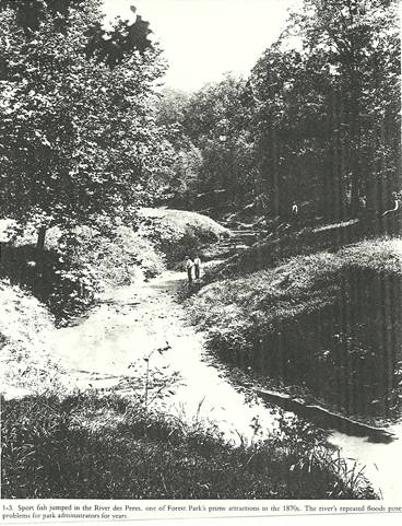
Figure 1. Fishing in the Park
The caption under the photo says: Sport fish jumped in the River Des Peres, one of Forest Park's main attractions in the 1870s. The river's repeated floods posed problems for the park's administrators for years.
In addition to the clear streams, the forest that gave the park its name was indescribable in its loveliness. The large trees stood as nature planted them. Cool winds gave a retreat from the oppressive heat of the city.
The Hippodrome: A one mile racetrack where the rich could check out their horses. It was located on the north side of the park just west of DeBalivere. No betting was allowed. They did manage a $200 cup for a prize. By 1877 or 1878 the track wasn’t used much. The track was opened to the public. I suppose that took the luster off it.
Commissioner Weigel did the best he could with the money available. He increased the labor force to 30. The men cleared undergrowth, deadwood, and stumps and filled up more than 60 coal pits and air holes left from coal mining of the 1850’s and 60’s. There was some debate about Clayton Road,
especially if they could continue to use it as they had for many years as a farm road. It can be visualized by the intersection of Clayton at Oakland, then thru the park to join the existing Clayton Road at Kingshighway.
People continued to enjoy Forest Park as they had before the separation, in spite of its remoteness and relative lack of facilities.
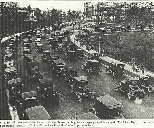
Figure 2. Automobiles in the Park
The caption reads: By 1923, the date of this Easter traffic jam, horses and buggies no longer paraded in the park. The Chase Hotel, visible in the background, opened in 1923. In 1929, the Park Plaza Hotel would open next door.
Back to top
Until the summer of 1885, the only public transportation to Forest Park was by train which stopped just outside the grounds on the north side of the park. This train was operated by the Wabash Railroad.
Even for people who drove, the trip to Forest Park was difficult. The best road to the park, Lindell, was a dirt road until the late 1880’s.
In 1881 a new twenty foot wide stone and iron bridge was built. (Clayton Road bridge). This could be the bridge over Clayton, on the west side of Kingshighway.
In dry weather park roads were sprinkled with water to reduce dust. Soon the water supply wasn’t enough, so in 1879 a steam pump lifted water from the Cabanne Spring to a 5000 gallon reservoir. This was protected by a rustic thatched shed. It was hard to keep up with the need, and in the summer of 1881 many plants died.
The nursery did well. In 1882 it supplied replacements for all the trees that died from the drought in the city parks, and included trees on the grounds of the Mental Institution, the Poor House, the City Hospital, and the Court House.
The Nursery in Forest Park and the Green Houses in Benton Park and Hyde Park provided the Park Department with all its plants that year.
When the city took over the park, the Cottage Restaurant which was the old Forsythe Farmhouse couldn’t make it, and in 1885 an ordinance awarded the lease to Charles Schweickardt who held it for 20 years.
The first streetcar line, a horse car, reached the northeastern portion of Forest Park in early June, 1885. This was almost nine years after the park opened.
The Wabash Rail Road offered five trips a day for 15 cents, But the street cars were cheaper and easier to use. They ran at least every half hour from 5:30AM until midnight. The adult fare was 5 cents. Children were half price, but even 5 cents was out of reach for the poor who needed the fresh air the most.
During one unusually hot summer, as city residents literally died from the heat. The streetcar company offered free rides from the baking streets and brick buildings to the cool shade of the park for children 10 and under. They had to be accompanied by an adult member of the family, and could ride upon presentation of a doctor’s certificate. If they could afford a doctor.
Things got hard to handle in the park so, on came the mounted police in 1885. A Mounted Police Sub Station was built in 1890.
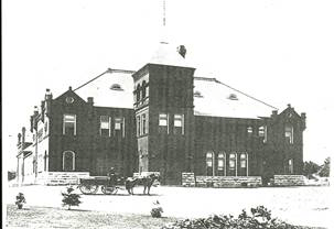
Figure 3. Mounted Police Station
It later served as a residence for park employees and briefly housed a Metrological Observatory. The location was, I think east of ball diamonds, across from the Highlands where the Science Center is now.
The Globe Democrat reported after a curfew was instituted (sarcastically); ”Since the construction of a streetcar line to the park, the youths and maidens have been thronging the lawns and "sporting" under the big trees and missing the streetcars. Now the superintendent of the park believes that moonlight and night are all bad for the young folks. And so the park is to be closed after 11:00, and the park police after that hour will start out and beat the bushes and blow horns to warn the lovers to hustle and get the last car for town. If the park is to be closed, it will put a stop to moonlight drives and wild orgies on the lawns in early morning”.
When the streetcars came to the park, each company had to spend at least $25,000 on its waiting room, which became city property as soon as it was built. The Lindell Pavilion opened by 1892 at the north central entrance to the park. The Laclede Pavilion opened in 1893 at the northeastern entrance to the park. In addition, the Missouri Pavilion, which seems to have been a less elaborate structure was located in the southeastern corner of the park.
The traffic in the park became horrendous, so in 1896 an ordinance provided some traffic separation by requiring “All persons driving any kind of vehicle, which included horses, bicycles, or tricycles, to keep to the right of center or risk a fine of 5 to 25 Dollars”.
By May 7, 1898, the cyclists got what they wanted, a cinder bicycle path. There was a great celebration.
In 1891 a new mounted police headquarters was built on 20 acres, a brick building and grazing land for the horses costing $46,000. The building took a year to build. It was on the site of what is now the Planetarium.
Clayton Road (Fox Creek Rd.) used to enter the park wherein it now ends at Oakland. It left the park on the east side of the park as Clayton Road, as it is now. Macklind entered the park at its present location intersecting Clayton Road and becoming Union Ave. to the north. It was named Second Kingshighway.
The Triple A Club was formed in 1897, which developed into a private club, though they denied it. Everyone seemed to find ways to use the park for their own pleasure. But some attempted to change the park. The park has now been refurbished, and Triple A was to be turned into a public course. Not sure if it every happened.
Back to top
THE PARK AND THE FAIR
In early 1890 a group had organized to procure a World’s Fair for St. Louis. Attempts had been made to have the Colombian Exposition celebrate the 400th anniversary of Columbus’ discovery of America. But Chicago won it.
They tried again and in the spring of 1897 the Missouri Historical Society took Pierre Chouteau’s advice and began serious consideration of methods of celebrating the Centennial of the Louisiana Purchase of 1803.
This time efforts in Washington were successful.
In June 1900, Congress authorized $5 Million, if the City of St. Louis would also appropriate $5 Million, and if another $5 Million could be raised by popular subscription. By March 1901 the conditions were met and the Federal appropriation was authorized.
In April the World’s Fair supporters incorporated as the “Louisiana Purchase Exposition Company” (LPEC). And in May they elected Mayor David R. Francis as President. In April 1901 a new Mayor, Rolla Wells took office. He was a friend of Francis so they worked together on the fair. On June 25, 1901 after much debate, Forest Park was chosen as the site for the fair. (Wonder what other sites were pondered?)
On September 3, 1901 the first stake was driven. It took until October 9, 1901 to take formal possession of the park. By the middle of October workmen were draining the lake and clearing trees. One of the men said most of the trees were 75 Years old, and some were 300 years old. Some of the stronger trees were transplanted. (I have a picture of this).
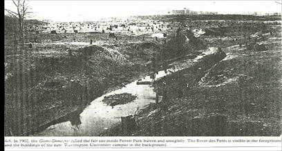
Figure 4. Preparing for the World's Fair
The Caption reads: In 1903, this Globe Democrat photo shows the fair site inside Forest Park barren and unsightly. The River des Peres is visible in the foreground and the buildings of the new Washington University in the background.
Just imagine, all the open space of the Golf Course was solid trees.
Two small Indian Mounds were found during construction. The items were deemed too deteriorated to save, so the mounds were leveled.
Also while workmen were preparing a working Coal Mine for the fair, it became unusually realistic when they struck coal at the site. This was approximately where the Zoo is now. If I remember right, people went into the mine and were allowed to try their hand at mining.
For months curious St. Louisans traveled to the park to watch the work. In late November the number of visitors were estimated at 100,000 people in one day. Many climbed the newly cleared hill where the Art Palace would be to gain a panoramic view of the fair site.
In April 1902 an iron fence was in place. The Globe Democrat reported that half of St. Louis stood on the World’s Fair site, while the other half peered through the fence without realizing they were free to enter. The fence was approximately at Hampton, which meant only half the park would be used for the fair. The Fair Grounds was extended to Big Bend and included Washington University. The University buildings were used, then returned after the fair. The Forest Park University was also used, then returned after the fair.
The eastern half of the park was kept open to the public and the 8 Foot wrought iron fence was built so those who couldn’t afford the price of 50 cents for entrance to the fair could look in. (Wasn’t that nice of them “They got to look in”). I wonder if that was just a poor explanation, or if the poor were really kept out?
Since the River Des Peres ran through the sites of all but two of the exhibit buildings it was agreed to re-route the river and to build a temporary wooden channel, and to shorten it by one half. The river had to be restored to its original state once the fair was over.
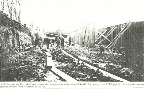
Figure 5. Changes for River des Peres
The caption reads: Because the River des Peres crossed the sites of most of the planned World's Fair palaces, the LPEC placed it in a wooden underground channel for the duration of the fair.
I have more pictures of this. Back to topThey went about $1 Million over the budget and it took half way through 1904 to make up the money. Also the completion of the fair was a year late.
From April 30, 1904 through December 1, 1904 more than 20 million people went to the fair. (An average of more than 100,000 for every day the fair was open.
The fifteen exhibit palaces were all outlined with electric lights and covered 128 acres of the 1,272 acre fairgrounds. The largest fair site ever. More than 9 hundred buildings including refreshment stands dotted the grounds. Twenty-Two countries were represented.
The U.S. Government built the Bird Cage which we still have.
A Ferris Wheel was moved from the Chicago Fair.
It could carry 1,400 people (40 people in each of its 36 cars) up 250 Feet over the grounds. The old story goes that it was buried for land fill near the waterfall close to Skinker Road.
The 1904 Olympics were held at the Washington University Athletic Field.
There were so many things to tell. The best thing would be to read the book “Forest Park”
I’m just hitting the highlights.
On November 26, 1904 President Theodore Roosevelt, who had opened the fair by pressing a telegraph key in the east room of the White House, arrived in St. Louis to visit the World’s Fair. He also had a carriage ride in Forest Park.
I would sure like to see some pictures of the President in St. Louis and the fair. It’s hard to imagine him being here and no sign of pictures. The background view would be of great help. From his arriving to his ride in the park, and whatever else he did.
Oh well, some day.
About six weeks before the fair closed, the LPEC appointed a restoration committee chaired by David R. Francis to draw a plan for restoring the park land. Opinion was divided. Some thought the company should leave some or all of the fair structures in the park. Others believed the company should remove everything from the park. The restoration of the park land to pre-fair conditions would be impossible and undesirable.
In May, 1905 after much argument and delay, the LPEC offered the park land to the city with enough money to cover the cost of restoration which was $100,000. The city refused saying the cost would be more like $300,000.
In July the LPEC offered and the city accepted a bronze statue of the city’s Patron Saint, the Apotheosis of St. Louis. While the officials wrangled, the work of removing the fair buildings from the park began. The Chicago House wreaking company paid $450,000 for the privilege of wreaking the temporary Fair Palaces containing an estimated 100 Million feet of lumber, 2 million square feet of window sashes, and copper wire worth $630,000. Much of the "staff" that covered the building exteriors was shipped to Venice, Illinois to be reduced to plaster, though some remained to be used as landfill.
As a side note, The Utah House was moved to the North/East corner of Nashville and Childress Avenues. Not sure of any others. This reminds me of the many houses that were built in the Dogtown area with lumber from the World’s Fair.
Many plants that had beautified the Fairgrounds were stored at a temporary nursery to await replanting on the restored grounds. Others were sold.
It was January 1905, when the LPEC employees discovered that a natural toboggan slope down Art Hill was clear of trees that were removed for the fair. Many people would enjoy this hill to this day.
As the wrecking crews fell behind schedule, LPEC did some of the removal work, then smoothed and graded the land and planted grass, shrubs, and trees near the Grand Basin. The Fair’s Sunken Garden again became a lake later called “Post Dispatch Lake". Between the two large bodies of water, ran a new lagoon. The crews left the Fair’s water and sewer systems for park use though some of the fire hydrants seemed oddly located after the fair buildings were removed.
The company crews left many of the fairs paved roads and added new ones for a total of seven miles of paved roads and more than five miles of dirt roads.
The River Des Peres became an open stream again after workmen removed its cover. A park employee reported in 1905, “The river which was formerly one of the principle landscape features of the park, has now become a public nuisance. Stench arising from the stream at times when the water is low, is stifling”. I have a picture of the building of this covered stream at the entrance to the fair.
The City’s Sewer Commissioner considered the necessary work on the 15 miles of the River Des Peres within the city limits the most important problem facing his department.
Improved access to the area west of the park, particularly by automobile, brought more changes. Washington University moved to it’s new buildings in 1905 after the LPEC moved out. Skinker Road was widened from Forsyth south to Oakland in 1910.
New subdivisions began to open on the land used for the fair. By 1911, although the park and the surrounding area had begun to fill, there was much open land. Around the park, the increasing numbers of automobiles made development possible during the next few years.
In 1909 they dedicated a fifty foot wide strip of land next to the park from Union to Skinker to the city for the use as park land, and as a road and a sidewalk extension on Lindell. But development lagged, probably due to the River Des Peres crossing the area. Also because the tracks of the Wabash and Rock Island Rail Road ran across the park crossing both Union and DeBaliviere at street level.
Inside Forest Park, many new facilities arose, encouraged by a new park commissioner. Like the park, the land around it changed as the temporary fair structures were dismantled. During the fair, the Pike Amusement Area had occupied much of the land north of the park and west of Union. A scheme to make the Pike Amusements permanent was abandoned after Washington U. officials objected. The developers then tried to attract buyers for the lots in the area where the Pike had been. Those were nice big lots and now hold large houses.
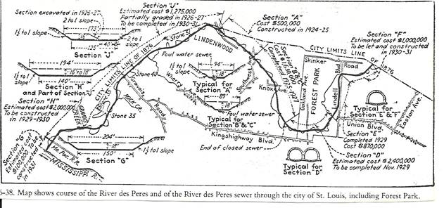
Figure 6. Map of the River des Peres
Back to top
In June 1906 the voters approved a Bond Issue, and in 1911 the city began construction of the Forest Park Foul Water Sewer. A pipe under the river through the park, built in three sections following the course of the river.
The section “E”, on the north side of the park cost $370,000 and was completed in 1929. The section “D”, from Union to south of Oakland was estimated at $2,400,000 and was to be completed in 1929. This is according to the little map in the book “Forest Park”. I also have pictures of the construction.
My final statement about the machinery being inadequate may mean I didn’t read enough.
On October 4, 1906 City and Fair Officials joined in unveiling the bronze statue of St. Louis in front of the museum.
In April 1908 the LPEC built four new bridges and offered to build a monumental entrance to the park at DeBaliviere. Instead, the City requested a shelter pavilion where it could sell refreshments.
On April 2, 1907, St. Louis officials moved quickly to get the proposed State Law Tax of two cents per $100 valuation. The tax passed easily.
The Cottage had closed when Schweickart’s lease expired in 1904, and it remained closed amid objections to the sale of liquor in the park. These objections were raised by such citizens as Anna Sneed Cairns of Forest Park University. So the City gladly accepted the LPEC’S offer for a $40,000 shelter atop Government Hill. It was called “The World’s Fair Pavilion”. The Pavilion still stands, just north of the zoo.
On April 7, 1909 the Board of Public Improvements and the LPEC reached a final agreement about the Fair Site. The LPEC had already begun construction of the Government Hill Refreshment Pavilion. If the company would finish the pavilion and would spend at least $200,000 on a monument to Thomas Jefferson, the City would consider the land restored.
The controversy was not quite over, since two sites were considered, one on Government Hill, and the other at the main entrance at DeBaliviere. That site won in March 1910, and the Pavilion continued on Government Hill.
On April 1,1911 less than three weeks before the LPEC charter expired, the company contracted for construction of the Jefferson Memorial which began immediately with a ground breaking ceremony on April 8,1911, and the cornerstone laying was on May 1, 1911. Construction took two years and cost about $450,000.
The building was dedicated on April 30, 1913, the Ninth Anniversary of the opening of the fair, and 25 years before construction began on the Jefferson Memorial in Washington D.C.
The arch at the center of the St. Louis building framed a statue of Thomas Jefferson by Carl Bitter who had been the chief sculptor for the fair. With the dedication of the Jefferson Memorial Building, the LPEC’s work was complete.
The Fair had brought great changes to Forest Park. Kessler said the park had received “improvements and betterments which fairly represent $500,000 of cost”. This estimate didn’t include the Art Museum, The Statue of St. Louis, The World’s Fair Pavilion, or The Jefferson Memorial. It just included landscaping, roads and bridges, sewers and water systems.
Kessler said “The restoration gives to Forest Park an impression of distance and magnitude that the old park did not possess, certainly there are no more impressive park views in the country than those afforded from Art Hill, and from Government Hill across the broad meadows, the lakes and the lagoons to the encircling sky line of the City”.
The Globe Democrat agreed that the work was a success. “Whether one looks up from the Memorial Building, all regret for the loss of the Primeval Forest vanishes”.
Even after the dedication of the Jefferson Memorial, the story of the World’s Fair was not quite over. After having served all outstanding obligations, the trustees of the former LPEC still held about $100,000.
In 1916, following the advice of their lawyer, they formed a Corporation called the Louisiana Purchase Historical Association to hold the remaining money as “An Endowment Fund for the benefit of an Historical Museum and Library, to consist of the Archives of the Louisiana Purchase Exposition Company”. The Corporation was merged into The Missouri Historical Society in 1925, as Francis Davis had long intended.
Back to top
DWIGHT F. DAVIS and SPORTS IN THE PARK
Dwight F. Davis' legacy (1911-1930): He became Park Commissioner when he was in his 30’s. He had a vision of the park. “The primary purpose of a park system should be the raising of men and women rather than grass or trees”. He said “If we can’t have the grass and the people, then let’s sacrifice the grass”.
He was an enthusiastic amateur athlete who was the outdoor men’s tennis doubles champion from 1899 to 1901. In 1900 he donated a trophy for a new tennis championship later known as the Davis Cup. Davis promoted and organized recreation, particularly in the poorest areas of the city.
In June 1903 Davis announced his retirement from tennis competition in order to devote himself to a private St. Louis organization working to provide playgrounds for the cities children. He worked with Charlotte Rumbold until 1907 when the association disbanded as the city park department took over the work. He then served as a Republican member of the city’s House of Delegates from 1907 to 1909.
In 1911 Republican Mayor Frederick H. Kreisman, who Davis supported, in turn appointed Davis as Park Commissioner. The City Council almost didn’t approve him. Some had another for the job, and others didn’t like him for being too friendly with the Terminal Rail Road, owner of the Free Bridge. Also because he opposed a City owned “Free Bridge”.
His political strength allowed him to put his Ideas into practice. One of his first official acts was to tear down the “Keep Off The Grass” signs of which there were many. As it happened, in 1876 there were no such signs, they had gradually showed up in the 1880’s and 1890’s.
By the 1920’s some had begun to call a halt to additions in the park which I think was a good idea. It’s just that Davis saw the parks as an ideal location for playgrounds and athletic fields for young and old. He was the driving force behind athletic facilities for organized sports. Of course this included the problem of Golf.
Racial barriers were restricting use of the Golf Course. Davis’ racial policy was never stated, but he probably provided separate facilities following the U.S. Supreme Court, “Separate but Equal” doctrine of 1896.
This was argued for years until 1922 when Albert H. Howard asked the Circuit Court to compel Commissioner Pape to issue golf permits to him and other blacks.
Pape’s solution was to reserve the golf courses on Mondays from 6:00AM until Noon “For the exclusive use and enjoyment for colored persons”.
Under Pape Forest Park contained 38 Tennis Courts, 20 Baseball Diamonds, 2 Soccer Fields, 2 Handball Courts, a Crickett Lawn, an Archery Range, and 2 Public Golf Courses.
Davis and his successors encouraged winter sports as well. When there was snow, department employees tended 2 Toboggan Slopes, a gentle slope on Bird Cage Drive which was closed to auto traffic to allow sledding, and nearby Art Hill where coasters could reach speeds of 35mph after park employees packed the snow then poured water over it. Gasoline lights showed the path for night sledders. Employees also smoothed the Grand Basin Ice for skaters and attended bonfires at the top and bottom of Art Hill.
Organized Sports began to grow in all fields. St. Louis swept the first National Municipal Tennis Tournament defeating the New York entries in September 1916 on the courts near the Jefferson Memorial. Here is a nice find:
Ted Drews teamed up with Fred Josties to win the Doubles Title, also Drews and Taylor won Singles Titles.
They had Golf Tournaments, Baseball and Soccer Leagues. A National Championship Bicycle Race, A Silver Skates Carnival where almost a thousand spectators stood six to eight feet deep around the Grand Basin.
As Park Commissioner Davis worked with Charlotte Rumbold on a city-run playground in the park. The outing lasted until 1909 when it got too expensive.
This did develop into a festival with displays of the children’s summer craft projects and simple athletics contests. Of course the competitions for colored participants were held at a different time from the white events. These festivals lasted until the 1930’s. In 1913 a pageant was added, and this developed into a Grand Pageant and Masque on a stage over part of the Grand Basin.
They enacted the history of St. Louis (150 years) with a cast of more than 7,000. For each of the four nights in the summer of 1914 an estimated crowd of 100,000 people filled temporary seats on Art Hill. This was a complete success, and voters did approve a new City Charter.
But the parks had a less important place in the City Administration. Approval of the Charter did not bring about the new community spirit Davis and Rumbolt had hoped to foster, since segregationists used its initiative provision to pass the Segregationists Housing Ordinance of 1916.
Municipal play day in 1916 was the second and last. The celebration was discontinued during WWI and not resumed. In 1917 the Municipal Theater was built with 10,000 seats including 1,000 free seats and has continued to this day. The new theater and the newly discovered Amphitheater on Art Hill were put to work during WWI for patriotic Gatherings.
One of the largest crowds ever in Forest Park went for a Liberty Loan Rally in 1918 to raise money for the war effort. A 350 piece band led by Lt. John Phillip Sousa paraded to the park, as did Veterans of the Spanish American War and of the Civil War.
They marched two and a half miles which took two hours to pass at any given point. They joined a crowd of 200,000 people on and near Art Hill, many of whom had walked long distances since the street cars couldn’t handle them. Sousa reportedly said that it was “not only the largest crowd I ever saw, but the greatest I ever heard of in the world”. The period following the war saw a noticeable decline in mass meetings in Forest Park, but the large crowds returned on Sunday June 19, 1927 when St. Louisans had something to cheer about. More than 100,000 people jammed Art Hill to welcome Charles A. Lindbergh back to St. Louis after his nonstop flight from New York to Paris. He had won the $25,000 Orteig Prize and made the pilot an International Hero, and also made the city world famous.
Back to topTHE ZOO
The Zoo continued to grow despite Davis’ opposition. He liked structured, supervised recreation putting the Zoo low on the list. But the people wanted it. In the beginning the animals were caged and in small, hot, smelly buildings. Davis preferred a “glimpse of a herd of animals roaming at will through natural surroundings”.
But with all the opposition, (Some didn’t want to be taxed), some didn’t want to give up 70 acres of park land. Anna Sneed Cairns complained that the roar of Lions and growls of Bears would scare the young women of the Forest Park College.
Despite the opposition, the City voted to set aside 70 acres for the Zoo which passed in December 1913. Davis contended it was illegal but took his place on the Board of Control and was elected President, a position succeeding Park Commissioners would hold until 1960.
So the build up came. July 1915 the Lion House, April 1916 The Elephant. To live there came “Miss Jim”. She came that same year, bought with the pennies contributed by school children. (My Grandfather Eric Taenzer arrived with her as trainer from the Circus). So many people came to see Miss Jim in the next three weeks, the enthusiasm grew and the tax came.
Miss Jim got her new Elephant House that year. The next structures were a chain of lakes which flowed into a new Seal Basin. The Bear Pits opened in 1921, 1922 and 1923. When Superintendent Angermeyer died in 1922, George P.Vierheller took over. In 1928 Vierheller became Director of the St. Louis Zoo, a position he held until 1962.
In 1925 the Primate House, In 1927 the Reptile House, In 1930 the Small Mammal Pits and the Bird House.
Back to 1916, Cass Gilbert drew a plan to enlarge the Art Museum, making it eight times the size of the World’s Fair Building with landscaping of Art Hill. The landscaping happened but not the Building. It took a lot of years, but it is now enlarged.
The other favorite hill was Government Hill which was landscaped through the years. In 1930 it received its colored fountain which was popular into the days of my youth. I think it has been restored again as of this year 2004.
THE SOUTH SIDE
In 1918 another attack on the Park Land. The City, trying to foster growth of the economy, set aside land near the Mounted Police Station for a landing field for Air Mail, despite objections to such use for park lands. The business community and the Chamber of Commerce supported an Airmail Field as important for the City’s development. They believed any other site would be so far from the main Post Office that it would take longer to get mail to the Landing Field than for it to come from Chicago.
The Chamber of Commerce donated half the $25,000 needed for grading the field and erecting a surplus army hanger. Major Albert Lambert, on behalf of the Missouri Aeronautical Society, agreed to contribute $3,000 for material needed to complete the hangar.
Airmail service between St. Louis and Chicago began in Forest Park on August 16, 1920. Pilots made one flight each way daily except Sunday, year round. To clear the area, they would circle the field gradually climbing until they reached their flight altitude of 1,000 Feet, then crossing the field diagonally to the Lindell-Kingshighway entrance.
The Airmail Service lasted less than a year ending June 30,1921 after Congress, bent on saving money, refused to underwrite Airmail Service deficits another year. The U.S. Government took back its movable equipment, but the Airfield and Hanger remained in the park. I think the hanger still is in use on the east side of the ball fields. Now used for Mounted Police.
Despite what St. Louisans would later say, it’s never been proved Charles Lindbergh flew mail out of Forest Park.
After Airmail Service ended, private pilots including William B. Robertson, Charles R. Wassall, and H. H. Hunter used the park for exhibition flights that attracted so many people, especially on Sundays that it was hard for the flyers to land. After the City prohibited the pilots from charging for rides in July 1921, Forest Park flights were no longer profitable. The pilots moved to a larger St. Louis County Field, which later became Lambert St. Louis Municipal Airport. The Forest Park field remained as an emergency landing field.
Another addition in 1919 was something for the poor. The Park Department and the Red Cross opened a vacation village on the parks southern edge for families who otherwise couldn’t afford to take vacations. The village included a hospital with a nurse, a mess tent where the average cost of a meal was 10 Cents, four showers, a children’s playground, and easy access to the Zoo. Fathers and other working vacationers could go to work using the nearby streetcar lines.
That same summer the Automobile Club of St. Louis opened an Auto Tourist Camp into the park near the vacation Village. The camp contained some tents and hammocks although most of the tourists carried camping equipment with them.
Things could have been worse for the parks southern neighbors if the City had not rejected Anton Steuver’s 1918 plan to mine fire clay under Forest Parks southern edge. Steuver’s Highlands Fire Clay Company, south of Forest Park offered to pay the city for the privilege of following a vein of clay under the park. He said it would otherwise have to move out of the city.
Mayor Keil supported the plan because it would produce revenue for the city without any damage to the park, while continuing to employ hundreds of workers. But a former professor of mining engineering said the mining might change the land into a series of sinks and shell holes. Neighborhood groups opposed the bill. The Central Trades and Labor Union was against it. The Globe Democrat called the mining a dangerous experiment that might work, but might not work. The Board of Aldermen approved the plan, then a week later unanimously reversed itself because of Public Opposition.
By late 1918, Lawyer Taylor R.Young had enough of these developments which he said decreased the value of his house on Oakland. He sued Commissioner Cunliff, challenging the use of land along the parks southern boundary for Triple A, The Mounted Police Station, The Aviation Field, The Greenhouse Complex, and the Tourist Camp and Vacation Village. He also called the Courts attention to “Unsightly and Unsanitary piles of rocks and stones along the south line of Forest Park near Skinker Road” and for good measure, challenged the practice of charging admission at the Municipal Theater and the contracts for refreshment sales.
Young’s case dragged on through the Courts for more than three years before a Judge dismissed it in 1922. In the meantime, the Aviation Field closed and the Tourist Camp followed. The tourists were unhappy with the facilities at the camp, and it closed in 1925.
In the early 1920’s development lagged north of Forest Park, and west of Union near where the river entered the park mostly due to the open (sewer) river and the Rock Island Tracks.
There were single family homes on the south and Apartments on the north side of the tracks
On another diagonal, the southern section of the west side and the northern section of the east side contained luxury apartments, mixed on the east side with hotels such as the Buckingham Hotel, The Chase Hotel which opened in 1922, and The Park Plaza in 1929.
In 1923 a bond issue for $87.4 Million for projects all over the city was passed. One of the projects was for turning the River Des Peres into a sewer. A billboard in Forest Park said “Think this over. What other big city would have an open sewer running through a fine big park?”. The proposal passed by more than 3 to 1. The river was rerouted so that it roughly followed the parks northern and eastern boundaries, then put into horse shoe shaped concrete sewer pipes tall enough to hold a two story house easily. Spectators went to watch a 300 Ton Shovel scoop up six cubic yards of dirt at one time. The sewer in Forest Park was completed in 1930.
The people on Skinker wanted a new entrance to the park, but instead got a widened Government Drive as part of a diagonal connection through the park. And again in the 1920’s the aroused public opinion prevented proposed construction along the parks southern border. Unlike Steuver’s mining plans, these proposals eyed land in the parks south-eastern corner made available by the removal of the River Des Peres. Whereas Steuver, who seems to be the unknown clay mines operator, had plans for all along the southern edge of Forest Park.
I may have mentioned this before, but there seems to have been more extensive “Coal Mining” in the park than originally thought. 40 coal holes were found while the park was being improved. It was seen as suspicious since Steuver was so interested in mining the park.
What I wonder is, was there any illegal clay mining under Forest Park. It would be hard to detect since the Fire Clay would have been about 100 feet down.
In 1931, a flower display started in one of the greenhouses. This continued until 1934 when park officials allocated $75,000 from the 1923 Bond Issue for the city’s share to build a new Jewel Box. The design was intended to admit the greatest amount of light in the winter to reduce damage from hail, and to reduce maintenance costs. Only the walls were glass. All of the horizontal surfaces were metal. Awnings regulated the amount of light, replacing painted windows.
Some called it a “Forbidding Block of Ice”. One well known contractor said it couldn’t be done. But Robert Paulus Construction Co. did the job. The new Jewel Box, officially named “The St. Louis Floral Conservatory”, opened on November 14, 1936.
There was no admission charge for any of the displays. The buildings design received National Recognition. The building worked just as City Engineer William Becker envisioned it would. When hail storms in the spring of 1938 broke more than a thousand panes of glass in the park greenhouses, the Jewel Box was undamaged.
The southeastern section of the park always had someone eyeing it. Plans for the park land continued to reflect the tension between nature and development. The southwest corner was always a target. Some wanted new buildings just like the 1920’s proposals for a new Psychopathic Hospital and a State Cancer Hospital, but was discarded after loud opposition.
Arthur A. Blumeyer proposed construction of a new Central High School in 1929. Commissioner Pape had another plan for the site, a Stadium. The Star Paper pointed out that a 50,000 seat stadium would increase traffic in the park and would mean more noise and confusion where it should be quiet and restful. Both proposals were dropped, then briefly revived in 1935 but reaction was bad and the stadium or school was never built there.
The park had its good times and bad times. The hardest were during the depression. The City’s financial condition, bad in the 20’s grew worse in the 30’s. Park Officials had to face increased use with inadequate budgets.
The assessed valuation of city property decreased by almost 20% between 1929 and 1940 resulting in lower tax receipts. A short work week was developed to spread work among a larger number of men working part time. By 1937 most department employees were working only fourteen days a month at three dollars a day. (Now I can see how the troubles started with my family, since they were so connected with the park).
An Army Recreation Camp prevented building in the southwestern corner until after WWII. The new highway, called the Oakland Express cut off the southeast corner when it opened in mid July 1936. The Army Recreation in that corner housed service men on leave from Fort Leonard Wood, Scott Field, and other nearby bases. It was the finest rest camp anywhere in the country. I can still remember the tents, especially those just off the sidewalk on Kingshighway. They were perfectly set in rows, with walks and all. I have pictures of this.
By the end of the war 30% of park employees were older than 75, and physically unable to trim the trees. After the war things began to turn around. The lights were back on, and the services cut during the 30’s were restored. During the 30’s, private money helped but the real source was Federal in several programs. These were CWA, FERA, NYA, WPA, and PWA.
This kept projects going and men working. Waterfalls, Floral Displays, Improved Lakes, Cooking Facilities, and Comfort Stations all for Picnickers. The City also found $75,000 from the 1923 Bond Issue to build the Jewel Box. The Zoo held its own, also the Museum, and the Muny (Municipal Theater). As time went by and money was hard to find, new ways were found to build up the Park, and buildings were included in the plan.
After many years, the attack continued. The Fire Warning System at Oakland and Kingshighway, Barnes Hosp. Underground Garage in the park tried to help keep it out of sight by discretely hide the exhaust vents behind bushes, and Tennis Courts. It’s nice, but still another piece of the park.
In 1975, perhaps encouraged by Barns Hospital's New parking lot in the park, the Solomon’s tried to get a parking lot in the park for the Arena. After much opposition, the lot was not built. The following year, the Children’s Hospital proposed a hospital expansion over several lanes of Kingshighway, some of which were part of the park. They had been used as city streets since the middle 1930’s. This started a great controversy. Who had control of the park, and what plan was needed?
The Planetarium was built on the site of the old Police Station. It had a lot of problems from the beginning until McDonnell Aircraft stepped in. Today an added attraction is the Science Center across Oakland Avenue which joined the Planetarium by a bridge over both Oakland and the Highway.40. People on the bridge can use Radar Guns to clock the speed on the highway.
The Jefferson Memorial has added an underground extension with landscaping and an atrium at the south entrance.
The Art Museum has expanded and will be doing more. The Zoo has greatly improved and expanded, but has generally stayed within its boundaries except for parking areas.
The Highway 40 was widened on the south and the north side.
Improved sports facilities such as hand ball, and tennis courts hand ball courts and tennis courts survive. On the east, Steinberg Rink is still being used. It opened November 11, 1957 as an Ice Rink that would stay open all year. The Mark C. Steinberg Charitable Trust paid 2/3 of the cost, and the City paid its share from the 1944 Bond Issue Funds.
The Jewel Box and the Muny have stayed the same from 1909 to 1917. The South Park neighbors looked with disdain at the Greenhouses and the Children’s Vegetable Gardens run by the Recreation Division. After the gardens closed, the City built a group of workshops for carpenters, painters, plumbers, blacksmiths, and auto mechanics. This brought all units together with the offices downtown. The tree nursery moved out in the early 1910’s, but the number of greenhouses grew, producing coal smoke when they were heated.
The question of the Triple A Club was not so easily resolved. The club claimed it had spent $100,000 on the park, and that they didn’t discriminate. Some debated that position, but nothing was solved, and Triple A stayed with a member’s only club. In 1925, the City altered the agreement with the club when they imposed fees for the use of the Public Golf and Tennis Facilities. Triple A agreed to pay $12,000 a year. $10.00 for each club member, the amount of an annual golf permit for the Public Course. The City then issued each member a Golf Permit, valid only on the Triple A Course. Permits for the Municipal Courses were not valid at Triple A, ending regular use of the course by Non-Members.(I believe the fight still goes on as of 2002).
In 1976 the American Institute of Architects Chapter invited a team of experts to come to St. Louis to study the park and make recommendations. They thought it should go under Regional Control, get the cars out of the park, and re-establish the Park Boundaries. This went over like a lead balloon. KMOX TV called the plan unworkable and said the voters aren’t about to give up control of the park.
So the story goes of Forest Park’s first century, ending as it began – in controversy. The discussion then was how best to preserve it for all generations to follow. It’s not sure how much of Leffingwell’s visions came down through the years, but it is remarkable how much of the 1970’s and 1980’s reflect the 1875 plan.
Today the County shares in a Tax Plan for the Zoo and Museum, and most of the attacks on the park have been stopped. There is a lot of park improvement by the Forest Park Forever Group of which I know nothing, except they are rebuilding bridges and repairing roads. Doing a general repair job. There is little doubt, given St. Louisans affection and concern for the park, that they will find a way to preserve the park into the 21st century.
This completes the long hard job of retyping Forest Park, as of 12, July 2004. Hope this has enough proper punctuation. The only other change will be to add something very interesting and if I run out of anything else to do. Read the book “Forest Park”. I just picked what was of interest to me.
Louis Schmidt
Back to top