The establishment of a settlement in Cheltenham (Dogtown)in the 19th century is essentially the story of mining and brick making. Those activities were not the absolute beginnings of this area's history as I've tried to make clear in other essays. However, it was the root of growth and stability and essentially defined the region from 1860 to 1900.
Dogtown is honey-combed with mines underneath the surface. Homes are built over the old mines throughout the neighborhood and as time goes on I hope to present better and better maps of the old mine sites. There have been occasional cave-ins and I'm searching for data on those as well.
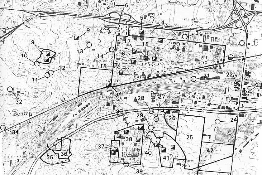
Below is first a map of the mine sites. After the map is an interesting list of 25 mines which operated in the area we today call Dogtown. Actually I
have been a bit generous in the geography here and have included a couple of mines that fall
outside my general boundaries. (See essay on the boundaries of Dogtown). I opened the
boundaries a bit since the mines were so completely central to the economy of this area in the mid 19th century
until at beginnings of the 20th century. This chart, adapted from a published list:
Garstang, Mimi. UNDERGROUND COAL AND CLAY MINES IN THE CITY OF ST. LOUIS.
Missouri Department of Natural Resources, Division of Geology and Land Survey, 1987.
This map and lsit has fascinating data on mines, their locations, depths and so on.
Please note that I have used the numbering system from this long chart. The chart is for all the mines in the St. Louis area, a list numbering 95 known mines. Only the first 21 and then numbers 31, 32, 33 and 34 fall into my somewhat extended boundary line.
MAP OF THE MINES OF CHELTENHAM (DOGTOWN)
Note: The number refer to the list and details of each mine below. #7 is especially had to find on the map. It is about half way between #8 and #5. #33 is actually off the map, just a tiny bit west of #34.
A different map of the mines may be found at:
Map of mines of Dogtown from 1905
LIST OF MINES UPDATED NOVEMBER 4, 2000
| THE MINES OF CHELTENHAM (DOGTOWN) | ||||||||
|---|---|---|---|---|---|---|---|---|
| Id Num. |
Name | Location | Entry | Depth | Commodity Thickness |
Dates of Mining |
Mineral | Comments |
| 1. | Chouteau Mine | Along Berthold near Kingshighway | Shaft | 30 foot deep | 2-4 foot | Coal | 1853 | |
| 2. | Hydraulic Press Brick # 3 | At Manchester and River des Peres (just near present day Macklind) | Shaft | 75 foot deep | 7 foot | Clay | 1896 | |
| 3. | A.C.Steuver Mine | Macklind and Berthold | Shaft | 90 foot deep | Unknown | Clay | 1909-11 | |
| 4. | Highlands Company Mine | Macklind, Cairns, Oakland and Berthold | Shaft | 26-28 foot deep | 2-4 foot | Coal and maybe clay | ???? | |
| 5. | Unknown name | Macklind to the Arena and south to near Manchester | Shaft | 40 foot deep | 2-6 foot | Coal | 1860s to late 1800s | |
| 6. | David Jones Mine | Forest Park beneath what are now portions of The St. Louis Zoo | Shaft | 25 foot | 2-4 1/2 foot | Coal | Early 1900s | Voids at 500-507 feet elevation |
| 7. | Unknown name | Beneath Deaconess Hospital | Slope | Unknown | Unknown | Coal | 1920s | |
| 8. | Gittins Mine | Between Clayton Ave. and Berthold, just west of Tamm Ave. | Shaft | 100 foot | Unknown | Clay | 1914-1917 | Controlled 26 acres and had three shafts |
| 9. | Highlands # 4 | At Louisville, West Park, Kraft and Villa | Slope and shaft | Unknown | 7 1/2 foot | Clay | 1937 | Once owned by Pittsburg Plate Glass -- Clay division. 7 foot wide, 6 foot high entry tunnels. |
| 10. | Missouri Fire Brick Mine | Kraft and Dale | Shaft | 44 foot deep | Unknown | Coal? and Clay | Unknown | |
| 11. | Grandview Fire Clay. Van Cleave mine | Dale near Louisville | Slope | Unknown | Unknown | Clay | 1909-1911 | |
| 12 | Missouri Fire Clay Mine | Louisville, north of Dale Ave | Shaft | Unknown | Unknown | Clay mine | 1911 | |
| 13. | "Diggings" | "Dogtown" Area | Shaft | 10-20 foot deep | 2-4 foot | Coal | Late 1800s | Numerous small shafts to reach coal for domestic use. Many shafts in residential basements. |
| 14. | Roberts (Hiram) Mine | Victoria, west of Hampton | Shaft | 75 foot deep | Unknown | Clay | 1911 | |
| 15. | Henry and Hiram Roberts Mine | Sulphur and Hampton | Shaft | 75 foot deep | Unknown | Clay | 1909 | |
| 16. | Berreshelm's Mine | Pierce and West Park | Slope | N.A. | Unknown | Clay | Unknown | |
| 17. | Mitchell's Mine | Pierce and Victoria | Shaft | Unknown | Unknown | Clay | Unknown | |
| 18. | Jones Mine | North of Manchester, Pierce, West Park and Sublette. West of Wrisburg | Shaft | 75 foot deep | 9 foot | Clay | 1883 | Possibly owned by Berresheim later |
| 19. | Evans and Howard #7 Mine. North pit | Wrisburg between League, West Park, and Lilly, north of River des Peres | Shaft | 45 foot deep | 1 foot and 11 | Coal and clay | 1896 | |
| 20. | Hydraulic Fire Clay Mine | Sublette and Berthold | Shaft | Unknown | Unknown | Coal and clay | Unknown | |
| 21. | Evans and Howard Mine | Howard Station on Mo. Pac. and Frisco Railroad. | Shaft | 50 foot deep | Unknown | Clay | 1855 | |
| 31. | Evans and Howard #11 Mine | The northwest corner of Manchester and Hampton | Shaft | 47 foot deep | 6 to 8 foot thick | Coal (?) Clay | 1911 | |
| 32. | Cheltenham Clay Company Mine | Forest and Mitchell | Shaft | Unknown | Unknown | Clay | 1916 | 5 acres controlled |
| 33. | Gilker Fire Clay Mine | The northwest corner of Manchester and McCausland. Immediately west of Matthieson and Hegler | Drift | 5 foot deep | Unknown | Clay | 1896 | Pillars robbed. 10-15 foot pillars. Entries 7 foot wide and 100 or 140 feet long |
| 34. | Matthieson and Hegker Mine | Northwest corner of Forest and Manchester | Drift | 4 1/2 foot deep | Unknown | Clay | 1863-1896 | 11 acres mined out by 1896 |
| Extra 1. | St. Louis World's Fair | Beneath lawn of the World's Fair Pavilion | Unknown | Coal | 1903-04 and ?? | |||
| HOME | DOGTOWN |
| Bibliography | Oral history | Recorded history | Photos |
| YOUR page | External links | Walking Tour |