TAYLOR CITY BELT LINE RAILROAD
THAT MYSTERIOUS LITTLE LOUISVILLE RAILROAD
Bob Corbett
Preliminary version: June 2000
I grew up in Dogtown and lived on Childress my first ten years. I was EVERYWHERE in that neighborhood, and often down in the "dump" behind our house at 1223 Childress and down the hill. Not very far down in the dump. I was
terrified of it. There were rats, lots of weeds and pricking things and perhaps poison ivy and who knows what. I did my assigned duty of dumping our ashes
and garbage in the dump and beat a hasty retreat.
This is precisely where this mysterious railroad is supposed to have run. Yet I had never heard of this railroad until about a year ago. The first person I have seen who's written about it in modern times was Louis Schmidt.
He wrote:
"I think I've found the mysterious railroad that I heard went up the east side of Louisville from the Mo Pac tracks. [It is shown] …on a map of the World's Fair, a railroad entrance at approximately the intersection of Louisville and Oakland.
The map showed the tracks, locomotive house, and coal chute. It was called "Taylor City Belt R.R." The tracks went alongside Valley Road (Dale), then along Sanford, and up a little valley which you can recognize on West Park where it makes a low dip just east of Louisville, then past Clayton, under a wooden bridge to the park. It then went around the edge of the Fair, then back to the entrance.
My cousin George Ode recalls the track, and remembers people waving from the train which went right behind his home on Louisville south of Wise. He also remembers a president on the train. The front of his home faced the tracks, and the back of the house now faces Louisville which didn't exist them. A station was on Nashville (6540) at the bottom of the hill. I've been told the tracks are still there (not verified) and no map shows the tracks outside the park. [Corbett
injects: I now have these maps, they are below.] There was a railroad map from 1904 that listed on the mileage chart "LOUISVILLE-NASHVILLE-ST.LOUIS--.15 MI. The Ode house is gone now, just a vacant lot with the old land fill in the back."
I do think the .15 miles is a mistake. Either it is a typo on Louis' part or the map maker. But the railroad would have been
1.5 miles. I would imagine the map that Louis originally saw was this one:
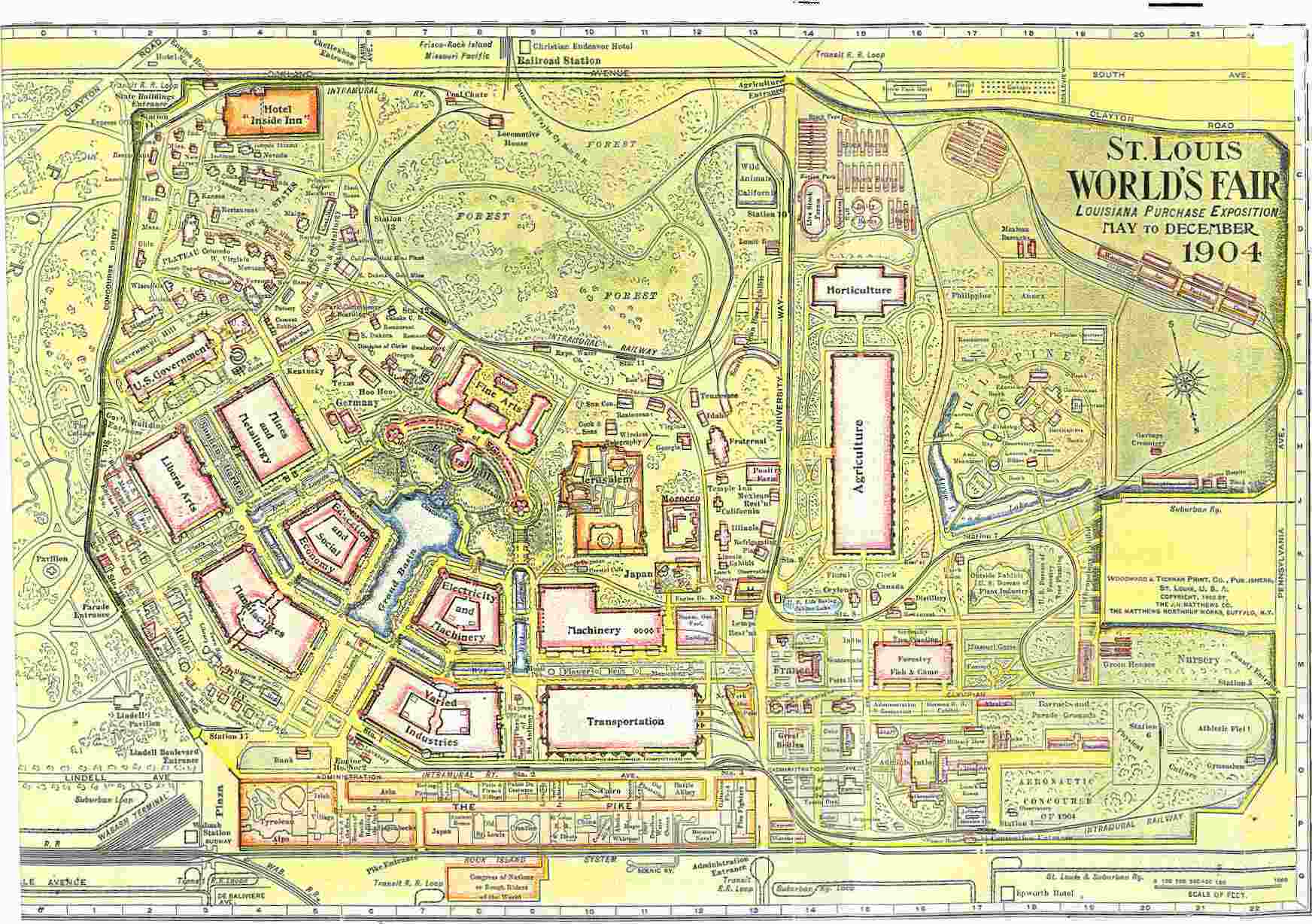
In Louis Schmidt's account he says he say a map with: [It is shown] …on a map of the World's Fair, a railroad entrance at approximately the intersection of Louisville and Oakland.
The map showed the tracks, locomotive house, and coal chute. It was called "Taylor City Belt R.R." If we
look at this map in a close up version of the top, along Oakland Ave., everything he saw is there,
the tracks, which, while having terminal tracks south of Oakland, also enter the park and run to the
warehouse area), a locomotive house and a coal shute." This is what makes me think this map or a close version of it, was what Louis saw.
Here's close up of the top:
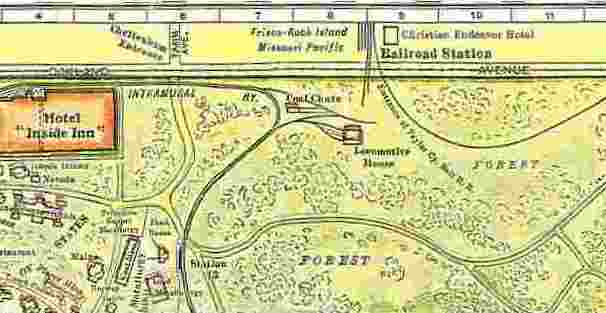
Now you can see the "Cheltenham Entrance" at Tamm Ave. The Frisco, Rock Island,
Missouri Pacific Railroad Station (which I am quite confident never existed), and
just below Oakland Ave, swinging to the west, where the track swings off to the west
toward the warehouse area.
Louis was mistaken when he looked at the map and thought the railroad actually swung
roung and circled the Fair. If you go back to the large map at top you might actually
think that and follow it with your finger even. I did in the beginning. However,
I call your attention in the close up to the Intramural just below the Cheltenham
Entrance and next to the huge Hotel "Inside Inn." It was the Intramural which cirlced
the grounds and there is a great deal written about it. The key piece of evidence is that
the Taylor City Belt Line was standard gauge railroad track, and the Intramural was a much
lower gauge track. More about that in a few minutes.
Louis had correctly speculated about the path of the train from Manchester, along
Dale for the couple of blocks until it reached where Lloyd is today, then up along
the one block of Sanford (that's the 1400 block of Sanford), and then following what was
a gully or dried up creek. If you walk this area today you can see at Wade, Nashville
and West Park where the street bottoms out just about 100 yards EAST of Louisville. That
was the most likely path of the railroad. However, when it left West Park it had
a relatively serious grade to make to be up to Clayton. Up to West Park the grade was
soft enough the trains could have made it. At this point it seems the train went into
a ditch that was dug-out to lower the grade, and thus it went beneath Clayton Ave.
There would have to have been a bridge at Clayton for the trains to get up the grade to get to the Fair Grounds.
It was Father Rauch, pastor of St. James Church, and a map buff, who first showed me a map
of the railroad track running from Manchester to Forest Park. Oh my, that was an exciting
day when I first saw that map. It isn't the best to show the route, but since it was the
first I had, I'll reproduce, in part, the original 1904 map which he has, and then show
a better view from a different map.
From Father Rauch's 1904 Map
From Father Rauch's 1904 Map
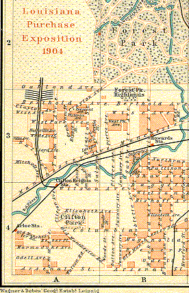 |
Note several things about the map:
1. Key: The bold doubles lines show track
running from Manchester to Forest Park.
2. This map also shows the non-existent railhead
at Oakland.
3. The redish/orange boxes east of the track are houses,
and the land which belonged to them.
4. The track runs between Childress and Kraft, at the end of
the Childress property lines.
5. As Louis said, from Manchester the track runs along
Dale (Valley), but neither Sanford nor Louisville existed at the time.
6. Note as well that this map uses a double line. The issue of
whether or not this was a DOUBLE line will crop up later. |
For the last map to establish the plans (at least) of the Taylor City Belt Line,
here is a detail from a map provided to me by Charles Duckworth.
From Charles Duckworth's 1904 Map
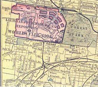 |
Note several things about the map:
- There are tracks running off both the Frisco and Missouri Pacific tracks from both the west and the
east sides.
- Given that these run directly from their main lines, these are certainly standard gauge track.
- Given that they are standard gauge track, they could not have run round the Fair circuit as
did the Intramural, since those tracks were smaller gauge.
|
The evidence seems monumental and gaining steam (no pun intended!).
In addition to Lewis' reports of George Ode's personal reports, I gathered a significant amount of Dogtown lore, but from more recent sources.
On Nashville, one of the cross streets the railroad would have crossed, there was a station master's house, and a neighbor who live across the street pointed out the drive way next door, which had once been railroad track.
On the next cross street, West Park, I had two reports. Danny Liston,
of Seamus McDaniel's fame, used to live at the bottom of the hill and had dug up some railroad spikes in his backyard. Another person one house away, living in a relatively new house, has some track and ties in his backyard, holding up a retaining wall, that were dug up when they dug the foundation for his house a few years ago. I did get a very brief look at that backyard, but the track I saw appeared to be of a much smaller gauge. It may well not have been connected to the railroad, but perhaps to some mining track.
On the next cross street, Wise, I have two reports from my own great
uncle, Jeremiah Corbett. One was to his grandson, my cousin, whom he told that he purchased the lot for the house from Missouri Pacific who had owned it during the Fair because it was train property.
He told my other cousin's husband (Henry Herbst) that next door was once a railroad when he was a clerk working for Mo. Pac (for whom he worked his whole life) during the Fair.
Both these reports come from Uncle Jerry many years ago before we had any interest in or knowledge of this railroad.
There are several reports (but no photos yet) of a wooden bridge over the
railroad tracks at Clayton Ave.
Thus, the grounds for believing in the train is supported by the visual images of the maps, and the reports rooted in Dogtown lore.
Next we get to the printed record, and it is quite impressive too. In fact, there are two pieces of completely convincing evidence. What remains in doubt is just the nature of the railroad. The evidence will suggest strongly that it never carried passengers.
There certainly were plans for a passenger service, but it does seem that this never came to be. Given the plans how could this be? The briefest story is this. I will try to marshal documentation below to suggest that Wabash (north side of the park with direct access to the Fair Grounds) wanted it all. The World's Fair planning commission just wanted the best service they could get; they wanted the southern route to Manchester and Mo. Pac. and Frisco lines. Some down and dirty dealing was going on and at one point in 1903 both Frisco and Mo. Pac were only shifting cars from their line to Wabash at Union Station, and threatened to stop this unless they were given a station and access to the Fair grounds. Then an announcement came out that passengers coming into St. Louis on out of town trains would be allowed to use THAT ticket on all local transportation to the Fair grounds. At this point both Mo. Pac. and Frisco announce they will NOT carry passengers, since they
hadn't been given any direct access. This is on the eve of the opening.
Thus it seems like perhaps Wabash kept their competitors at bay, and once there was no money to be made on passenger service (in 1902 they estimated 25,000
passengers AN HOUR on the Manchester route), then Mo. Pac. and Frisco backed out.
If all that is so, then the Taylor City Belt Line existed only for freight. But, did it carry the freight just to a railhead at Oakland or did it go onto the Fair grounds and over to the warehouses area?
At any rate, let's look at the evidence I have managed to collect.
I'll start late, since this piece is quite interesting. Henry Herbst, a collector of materials on the Fair, has an unusual book from 1913, a full 9 years after the Fair ended, which is a two volume assessment of the Fair and its finances and other details. In that work Henry found the following:
Taylor City Belt
The Universal Exposition of 1904
David R. Francis
c1913
Chapter X page 640
Department of Traffic
"The construction and maintenance of railroad tracks within the exposition grounds constituting the terminals of the exposition were under the supervision of the Division of Works. During the construction period the track was confined to the immediate needs of the contractors. These tracks were permitted to remain and were subsequently used in the work of installation, in the operation of the intramural passenger line and later in the removal of exhibits. Interesting details of the work of the department are given in the following extracts from the report of Mr. Allen:"
"A depot was constructed at the connection of the Colorado railroad for the purpose of handling exhibits arriving at the grounds in less than carload quantities. A city receiving depot was constructed at the southeast entrance to the grounds for the purpose of receiving supplies arriving by vehicle or electric cars destined to exhibitors and concessionaires within the grounds."
"A classification yard comprising tracks having a storage capacity of about 400 cars was constructed on the plateau west of the Philippine reservation. Railroad connections were made with the Rock Island company directly west of Skinker road, with the Wabash company at the main or DeBaliviere entrance and with the Taylor City Belt near Tamm avenue on the south side of the grounds. The Taylor City Belt was organized jointly by the Frisco and Missouri Pacific companies, joining these two lines directly south of the grounds, thus affording us three railroad connections through which deliveries were effected."
How could anything be more clear, and this was from a document written AFTER the fair. It does lend some very strong evidence that the Taylor City Belt line did exist at least for delivery of materials.
We do need one more map here, since some of the maps show the track continuing on from Oakland Ave. near Louisville to this storage area to the west.
Let's look at one. It's a map we've had before, but I treated it differently.
Detail of World's Fair Map
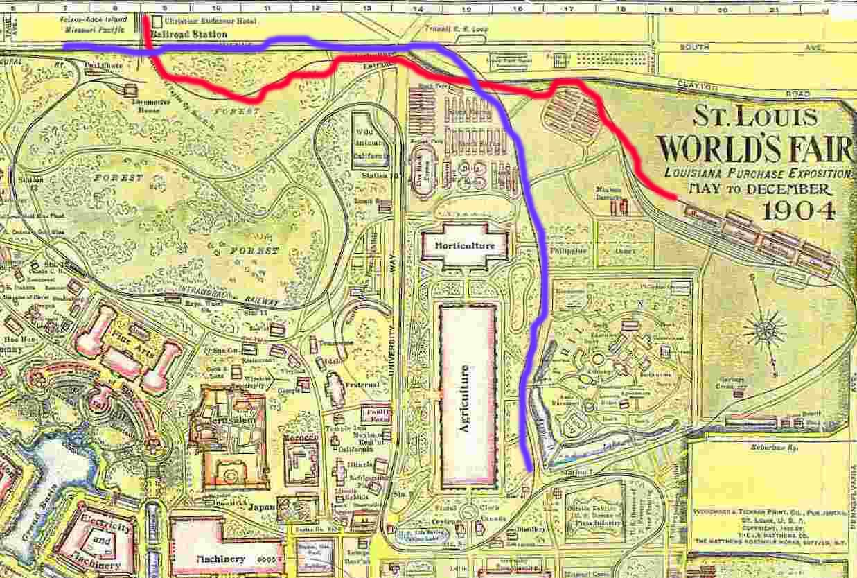 |
Note several things about the map:
1. Key: The Taylor City Belt Line tracks run over to the
warehouse area, which I have marked with a red line.
2. Note as well the route of the Intramural. The tracks do NOT
intersect with Taylor City Belt Line. This should dispell any notion
that the Taylor City Belt Line was ever intended to circle the grounds.
3. For that matter, if you go back up to the top of the Intramural line
note that it doesn't reconnect up to where the Taylor City Belt Line
enters the grounds.
4. However, I have maked in blue the Oakland Avenue street car tracks which
not only served the Tamm/Cheltenham entrance, but did run down to stop # 7
on the Intermural and thus made transfer possible. |
In March of 1902 in the World's Fair Bulletin (vol. 3 # 5, page 10)
we read:
"Much street and steam railway construction is in progress in the district surrounding the fair. During the most severe winter weather the steam railway companies serving the site made surveys for extensions, and built switches and storage tracks, so that by spring the tracks of four main trunk lines, as well as those of the Terminal Railroad Association, will supply access for material and freight to the site. These main trunk lines are the St. Louis and San Francisco Railroad, the Wabash Railroad, the Missouri Pacific Railway, and the St. Louis Line."
One reason given for choosing Forest Park was:
"The location of the World's Fair upon Forest Park site would give direct connection to the Union Station of the double track of the St. Louis and San Francisco Railroad, the double track of the Missouri Pacific Railroad…."
"The St. Louis and San Francisco and Missouri Pacific, with their double track lines, would handle about 25,000 passengers per hour from Union Station to the World's Fair grounds….In addition to this, the St. Louis and San Francisco, Missouri Pacific, Wabash and St. Louis Kansas City and Colorado Railroad can deliver all passenger business outside the city direct to the World's Fair grounds."
Oh goodness, 25,000 passengers an hour. Dogtown would have been a circus grounds! I had read that my first time through as 25,000 a DAY and I thought that was hilarious. The figure seems a pipe dream. It appears the track was a single track. 25,000 people is one heck of a lot. It doesn't seem possible. However, the story indicates DOUBLE TRACK LINES. It's not clear if they mean
to Manchester and Dale, or to the Fair grounds. It would have to be the latter, but could there have been a DOUBLE track all the way to the Fair? This is why the map above,
the one Father Rauch loaned me, is important. It does picture a double track line. Perhaps that's what they had. Howerver, that
raises some questions with gully along Louisville. The current depressions where I've speculated the tracks went simply don't seem
wide enough for a double set of tracks.
However, where everything begins to come unraveled is from a report in December of 1902 which I found, most curiously, in a Buffalo, New York
newspaper, but which was reprinted in some New York papers. I haven't checked the St. Louis papers for this period. It reads:
From Buffalo, NY newspaper Dec. 12, 1902.
"The Missouri Pacific, St. Louis and San Francisco and Colorado Railroads has served formal notice on President Francis of the Louisiana Purchase Exposition Company that unless some satisfactory agreement was reached with them for the movement of cars on the terminal lines leading into the World's Fair site, they would refuse to switch any more cars into the grounds and would withdraw their motive power. This action will compel the directors to agree upon a basis of compensation to the above railways for switching charge or else buy a number of locomotives."
So what does this story mean? It's a bit confusing. Okay, on many of the maps there are the railhead tracks on Oakland. One interpretation is that the three railroads were bringing cars to THAT point with their own engines and using their
engines to switch the cars to engines which were on the Fair grounds, and that these latter delivered the goods to the warehouse on the Fair grounds. In this process the three off-Fair railroads were not making the bucks they wanted.
Further, what would it mean that the directors would have to "…buy a number of
locomotives" if Mo. Pac and Frisco pulled out. How would they get the freight TO
the rail head? Surely if the two railroads were pulling out they wouldn't allow the use of their track. This report is a bit confusing.
Or, it might mean that while awaiting access to the Fair they were doing this transfer of freight to the Wabash cars down at Union Station, and thus losing out on their share of the wealth.
Whatever was going on, it does throw some doubts on how to understand the role of the Taylor City Belt line. However, we don't want to forget that this report
is December 1902. That's still fairly early. Maybe not. Construction would have to have been quite advanced by that time, and the freight was mainly for the building
of the Fair itself. Perhaps that's not so either. It would have taken lots to supply the Fair on a daily basis. The report that somehone
told me about, that fuel to supply power to the Fair came from coal on the Fair grounds, or at least Forest Park mines, seems far fetched to me. The Fair grounds
would have eaten up coal fuel for power like wild. It would have to have come from outside. That would
have meant constant deliveries throughout the Fair.
Throughout the period of the Fair the movement of people was a major concern and much discussed in the newspapers. In the St. Louis Republic of March 26, 1903 we read about the streetcars preparing for the massive crowds which would be coming with the Fair. Of special concern was "Dedication Day," the first day in which lots of VIPs would attend and the general public would flock to the grounds. The newspaper report says:
"In view of the commonly expressed belief that these facilities (streetcars) will be totally inadequate to handle the crowds who will go to the grounds in the morning and return in the evening on Dedication Day and during the World's Fair, it was
thought that the Missouri Pacific and Frisco systems would provide terminal facilities at the grounds or make an attempt to do something toward helping to handle the crowds. The Missouri Pacific and Frisco are owners of a belt line, which is at present used by them to transport freight to the Fair grounds from their tracks which are over a mile from the park….."
"Questioned in regard to using this line for passenger traffic, an official of Missouri Pacific stated that at present it is practically out of the question. 'We will make no effort towards having a World's Fair terminus,' he said, 'unless it is clearly proved that the means already provided are totally inadequate and threaten to jeopardize the success of the Fair. In that case we will do what we can."
This passage, especially the penultimate paragraph, is solid evidence that the freight portion of the Taylor Best Line was functioning. It does seem quite solid that at least until this time the passenger idea had fallen away.
The last piece of data I have to present at this time is from:
OFFICIAL GUIDE TO THE WORLD'S FAIR. Issued by Official Guide Co. St. Louis. Published by authority of Louisiana Purchase Exposition by W.B. Conkey Co. Chicago, 1904.
On page 18 we read: "South railroad entrance is served by the Taylor City Belt Line Steam Railroad, supplying access for the St. Louis and San Francisco and the Missouri Pacific Railroads."
On page 13: on steam railroads: "The southern side of the grounds is reached by the Taylor City Belt Railroad, a corporation which services the St. Louis and San Francisco and the Missouri Pacific Railroad."
I did have a letter from director of the Union Pacific Railroad Museum in Omaha (Union Pacific eventually ate up Missouri Pacific). He wrote that:
"According to Poor's Manual of Railroads for 1903, the Taylor City Belt Ry,
was opened for business in September 1902 and built two miles of track to
connect the Missouri Pacific and the St. Louis and San Francisco RR's, with
the World's Fair. It was jointly owned by the two railroads but apparently
operated by the Frisco. There is no further information in Poor's so what
locomotives and rolling stock they might have owned I cannot say. Perhaps,
because it was to be such a short lived company they leased equipment from
the two parent companies. If it connected two standard gauge rail lines
there is no way it could be anything but standard gauge itself. As to
handling the grade you could use multiple locomotives if needed. Because
of the volume of traffic to the fair I cannot imagine this line not
handling passengers. I assume the trolley line went to the fair, but its
capacity could not begin to handle the volume. I don't think I have any MP
public timetables for 1904 that might answer that question. There are some
old MP employee timetables at the Museum of Transport in St. Louis that
might show passenger service to the fair."
So that's where it stands. The was for sure a Taylor City Belt Line which ran from Manchester to at least Oakland Avenue and probably on to the warehouse area of the World's Fair grounds. It seems that it is likely that it did NOT carry passengers though it was originally intended to. Since it was also intended to also carry goods AWAY from the Fair after it was over, it is likely that the existence of this line continued as late as 1905.
I have few leads, but will continue to search and would appreciate hearing anything any of you out there might add.
Bob Corbett
June 2000
Bob Corbett
corbetre@webster.edu


