MAPLEWOOD
This area is the western edge of the "Gratiot League Square"
James Sutton purchased 314 acres in 1826 from the Charles Gratiot Estate. The price was $1.00 and a bit per acre. (A bit was 1/4 of a dollar coin). I've read somewhere they actually cut the coin into four pieces. (No paper money yet).
Sutton was a St. Louis iron-monger, hardware merchant and blacksmith. He wanted to move his family to a quiet, rural environment.
They first lived in a log cabin near the present Commonwealth Avenue. In 1835 they moved into a stone house on the road to Jefferson City, by the way of Manchester. If I remember right, Manchester tied in with Highway 50, which went to Jefferson City.
Figure 1. Sutton Home
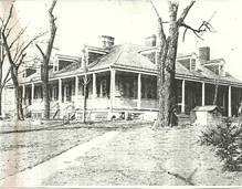
The Sutton house was later given the address of 7453 Manchester. His blacksmith shop was at the corner of Manchester and Big Bend. Some of his neighbors were: Charles Rannells to his west. Rannells called his settlement "Laclede" which went to Hanley Road.
The Pacific R/R put a station there in 1853 at the southern branch of River Des Peres a little beyond Sutton's property.
To Sutton's north was a tract named "East Laclede" owned by the Gay Family. Further north was land owned by Jean Baptiste Bruno, a French market gardener.
Figure 2. Bartolds Grove Roadhouse
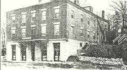
In 1840, Henry Bartold, a German, put up a three story stagecoach stop and a tavern at Manchester and Deer Creek. It was named "Cool Valley Tavern", later changed to "Bartolds Grove Roadhouse". Valley Post Office, the first in the area, was located there.
A two room "Valley School" was also located there. It had a Picnic Ground that was located behind the building.
My memory fails me about the arrangement of schools for the Maplewood/Richmond Heights children. This may require more research. I believe they started with Valley School, then later to the Benton Branch School at Manchester and McCausland, then to Maplewood when the city boundary was moved beyond McCausland.
From a Franz Park homecoming booklet of 1989, an article about the Maplewood Baptist Church tells about their Sunday school being formed in 1891 with 30 students. This was in a schoolhouse at the then Valley School located at Manchester and Bartold.
An 1878 map shows Bartolds Grove on the southeast corner of Manchester and what is now Hanley, with Valley Post Office on the north side of Manchester.
An 1890 rail map also shows Bartolds Grove south of Manchester at Hanley Road. I originally thought of Bartolds Grove being on the north side of Manchester.
James Sutton died in 1877 at the age of 80. Before his death his son Henry L. Sutton was chosen as presiding judge of the County Court in 1876. The first three meetings of the court were held at the Sutton home.
James Sutton's land was divided among his nine children. His daughter Mary Marshall sold some of her land in 1890 to a real estate company. This was platted for a subdivision and named "Maplewood" because of the maple trees along the streets. (Note the name "Marshall").
Another daughter, Sarah Harrison opened the "Maple Lawn Addition" west of Sutton Avenue.
Her sister, Kate Thomas started "Ellendale".
The property of one son, John L. Sutton became "Lohmeyer Heights".
Charles W.Sutton sold his land south of the railroad tracks to Moses Greenwood.
During the early 1890's transportation to these suburban areas was by "Accomodation Trains" on the Mo/Pac R.R. Stations.
These were "Ellendale" "Maplewood" "Sutton" and "Laclede".
Electric Streetcars on Manchester arrived in 1896. Loops were established at Yale Ave. the “City Limits” and on Sutton at Maple. This attracted many new residents.
Maplewood was incorporated in 1908. In the 1910 census it showed a population of 4,976, and by 1950 the population peaked at 13,416.
By the end of the 1920's Maplewood had 250 stores, mostly along Manchester from the City Limits to Big Bend. Satellite shopping strips were along Sutton and Greenwood.
The city's industries included Sunnen Products, Mississippi Valley Steel, and Cupples Products.
Figure 3. Maplewood Show
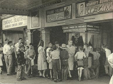
Maplewood was more my playground than the city. As a child, I remember the Maplewood Show and The Powhattan Show with the outdoor screen. You would see the first show inside, then during a break they would open the side doors, after that you would move outside for the second show.
My Uncle Gus Schmidt lived on the street just south of Greenwood, and of course somewhere east of him was our old family doctor "Dr. Brozart" (not sure of the spelling). I can remember going to his farm somewhere in South County. It had a spring where they kept the beer and milk cold. Can remember large crowds being there for breakfast. All the men sat around a large table and were served all the eggs they could eat, which they ate as fast as the women could bring them. Never saw so many eggs ate since.
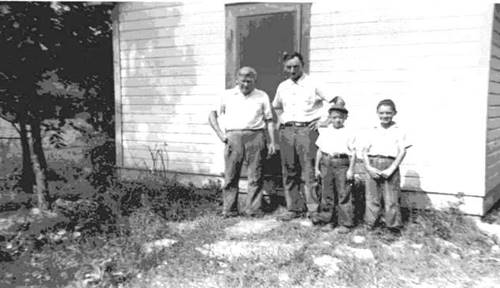
Figure 4. Greenwood Home
I remember the good doctor thought we were pretty sickly looking, and he mentioned how we needed the air. And the best way to do that was to cut his weeds. We were skinny kids, never did recover from the depression.
The places that stand out most as I grew up were:
The Maplewood Show, the Pool Hall, and the Chicken Store where they cleaned the chickens right there in front of you. That was the worst smell I can remember. The Bank (could be Peoples Bank) was on the northeast corner of Manchester and Bellevue. It must have been the first bank in Maplewood. My Dad sure hated to see it torn down.
The old Hardware Store across Manchester from the Citizens Bank. The old Dance Hall we used for many parties. It was somewhere upstairs, over maybe the Hardware Store, or not. The Katz Drug Store, and Bettendorf’s (grocery) Store with its basement shopping and the removable baskets you would put on the conveyer belt, then pick up the basket upstairs and finish shopping.
As a youth, it was the Saratoga Bowling Alley (with the pool tables which I preferred), Ted's Corner, and of course the Bars.
The last three years of High School I worked three nights a week and Saturday at Jim Remley's Market on Big Bend. The trouble was I had to walk from home. Didn't make much money. Didn't have a car until a year after graduation.
That is generally what I remember. There is a lot more, but it's hard to remember the names, even with the places that stand out in my mind.
There is something that seems strange as I redo this. The fact that there are no Clay Mines listed for Maplewood. Could it be James Sutton didn't allow mining under his property? This is just a thought (Dec.2004).
This seems to be a lot more information than I have about Maplewood. Suppose it's because of the Richmond Heights Library. The collection of private histories made it a gold mine.
Richmond Heights incorporated in 1913, which seems like a young puppy. It adjoins the north side of Maplewood, and shares a high school named for both communities.
The eastern part of Richmond Heights was part of a Spanish Land Grant to Charles Gratiot. Of course it was called "Gratiot League Square". Its boundaries were Kingshighway to Big bend, and from a line through 3/4 of Forest Park to Pernod on the south. Bob Corbett has the west boundary as McCausland Avenue.
After the death of Charles Gratiot in 1819, two strips of this land were inherited by Victoire Labbadie. (From Oakland to Wise). Paul Gratiot inherited the strip (Wise to Dale).
By the 1850's, Peter Lindell owned the western half of Victoire's land which was being subdivided.
The owners in 1878 were:
M.D. & L.W. Patchin, 18 acres at the city limits.
Albert Lindell, 8 acres.
Thomas Wright, 8 acres.
Clara Balcer, 34 acres.
John Baker, 16 acres to Big Bend.(Pennsylvania).
Paul Gratiot's land was also being subdivided. His land was divided into approximately 20 acre lots from the City Limits to Big Bend.
The owners in 1878 were:
Henry Staats, Francis Cabanne, Alfred Brancourt, and Jacob Macquat.
Note: Francis Cabanne may be the key to the next story.
Frederick E. Niesen, a wealthy St. Louis Real-Estate man strayed while quail hunting in 1887. He loved the area so much, he purchased the property from Armand Francois Robert, the Count DeGiverville. An heir by marriage to Francis Cabanne I think. Niesen built a frame mansion in 1892. The address became 1234 Bellevue much later. This was on the N/E corner of Dale and Bellevue.
I believe this was the old Staats and Cabanne plats of the 1870's totaling 40 acres. The boundaries being the City Limits to Sunset and Dale to Wise.
Over the years, the Niesens added two other homes to the five acres they reserved for their family compound. The two younger daughters, who became a Kramer and a Forshaw, lived in these homes. The houses were arranged in a semi-circle. The rest of the Niesen tract was divided into residential lots, and developed by Niesen as "Bellevue Square".
The Niesens retained ownership of this land until, I think, Highway 40 took most of it. The family then sold the remaining property and the house to St. Lukes Parish. The property from Dale to the highway is now the Churches Athletic Field.
South of Dale, James McCausland owned 162 acres where St. Lukes Church is now. He is never mentioned in the history of the area. I have a map showing him as owner in 1856, and 1878. But there is no indication when he sold it. The property went from McCausland to Big Bend, and from Dale to Glades.
The only mention of the property is that John Rankin Dyer owned 120 acres south of Niesen. That is a little short of McCausland's' 133 acres, but close enough. (My figures don't jive here. Need to re-check this).
In 1900, McCausland teamed up with Niesen to promote the area. The Almand Niesen Realty Co. was formed. (This doesn't figure either). This also comes out strange: As land owners died or left the community, their land reverted to this company, which in turn subdivided the farms to contractors. The contractors were under strict supervision and restrictions, mostly to keep the area residential only.
This was a battle through the years on many occasions until reality set in. They needed a tax base. The area was difficult to keep exclusive.
The plat south of McCausland's was owned by John Pierre Gratiot, who then sold to Jean Baptiste Bruno in the late 1850's or early 1860's.
Bruno was a French market gardener. An 1872 map shows the owner to be John B. Bruno. (He must be Jean Baptist's son, or not.). This was 52 acres from Bellevue to Big Bend and Glades to Bruno. John Bruno and Dyer were the main developers of this land. Two buyers were; A.S. Curtis with 17acres on the east side of McCausland, then George Rogers with 15 acres.
During the next decade the Niesens were joined by only 18 families. To name a couple; the Henry Buehning home on the N/W corner of Glades and Bellevue (1701), was built in Oct.19,1899. Also the home of Dr. Charles H. Highes on Hiawatha. (No other information).
Another book, "Down Memory Lane" stated, the Brown Home at 1601 Bellevue was the second house to be built in 1904. There was widely scattered homes on private holdings and tenant farms.
Another was the Campbell's Forest Home. George Campbell owned the property and ran a reputable park. At the entrance there was an immense steel tower with electric lights across the top.
I found the home did exist in 1919 at the southwest corner of Clayton and City Limits, just outside Richmond Heights. The farm actually went from Oakland to Wise, and from Bellevue to City Limits. There was a three story white frame house which stood on a spot directly across from the north end of the present (St. Mary’s) hospital laundry, in line with the east walk. A fish pond occupied the space where the intern’s residence is built.
This property had a forested picnic area. It could have been tied in with the West End Heights Amusement Park at High Point which opened around 1895. This park burned in 1914. The farm road Clayton, made it easy to reach.
I have been trying to find the name of the Post Office on 7130 Oakland, which turned out to be "Park Avenue Post Office". This fits as it should.
During the Civil War, this land was the site of an arsenal for the Union Troops.
Historians of the war indicate Confederate General Sterling Price hoped to capture this arsenal so he could barrage the city of St. Louis, but this failed. This info never has been proved in the official minutes of Price's raid.
All of the information of the raids on St. Louis were more or less "local lore". The official records do show Price wanted to capture St. Louis, but found it too well fortified. There are only brief mentions of patrols on St. Louis, nothing more. Price probably wanted Ammo. Did he get it? There were a lot of southern friends in St Louis.
Price turned, then pushed on as far as Pacific, Missouri where a hastily organized band expelled them from the vicinity. See my document on the Civil War.
The children of Richmond Heights played in the old Union powder houses. The open field to the south of Campbell’s was used as a drill field. So there must have been a rather large contingent to fight off the southern raid.
This makes me think of the story of southern troops raiding the Muegge Store at Dale and Manchester. I think the two raids are tied together. The store may have been a diversion. (Just speculation).
The Campbell Forest Home became the "Monte Carlo" of St. Louis. It was operated by two of St. Louis' most colorful gamblers. "Kid Becker" (king of St. Louis Gambling), and "Tony Foley" (member of the notorious Bottoms Gang).
It was a thorn in the side of Richmond Heights, and located just outside of the City Limits and operated from 1917 to 1920.
Of all the Barrel Houses, Lid Clubs, and Floating Saloons in that war era, the Forest Home was the most trouble. It had Dice-Tables, Roulette, High-Stakes Poker Games, and Horse Betting. This put it under the most vigorous of Civic and Church attacks, also attacks from St. Louis Newspapers.
To add to the trouble, during the winter months they allowed Gypsies to camp in the park. This caused the neighbors to refer to the campsite as "Van Camps".
In 1919 that small strip of land from Oakland to Clayton was annexed by Richmond Heights. It was hard to remove the gang, until a mysterious fire destroyed the main building. This hurt the gamblers, but they held on for another year in a reconstructed pavilion nearby. They finally gave up, and in 1920 the "Sisters of Mary" purchased the site for their hospital which opened in 1923.The Hospital still stands, much improved and going strong.
The Forest Home experience left its mark on the laws of Richmond Heights. They ran a tight ship with tough ordinances. No Pool Rooms, Limited Taverns, $300.00 limit a day for betting, and a Dry Law from 1912 to 1937. By the time of my running days, things did change.
The farmers of the area’s claim to fame was in growing the finest variety of asparagus found in this section of the Mississippi Valley.
From the earliest days, Clayton Road was the farm road to St. Louis, which later caused a problem in Forest Park. The roads were dusty, and people using the park complained about the traffic. Eventually Clayton Road stopped at Oakland near Hampton.
The old "Dinky" Streetcar was built and run by the old "United Railway Company" for the Richmond Heights Area. It ran from the West End Heights Amusement Center at Hi-Point, down McCausland to Wise, West on Wise to Highland, South across Dale, and finally looping at what is now the corner of Lindbergh and Silverton Drives.
I don't see a date on this, but know for a fact there was no streetcar on Oakland till later.
This area became more accessible to St. Louis with the completion of an electric streetcar line along the southern edge of Forest Park in 1895. It looped at West End Heights Amusement Park at Clayton and McCausland. In 1910 the line continued on Oakland, left on Bellevue to Wise. It then joined the Richmond Heights Line, and went on to Brentwood.
About the same time, the St. Louis Cross County Railroad opened a line from Hi-Point to a junction with the Clayton Line at Wydown Blvd. and DeMun. This was the beginning of the City-Limits Line, which was extended southward to Maplewood in 1918.
As I re-read this, I remember the fun we had on Sundays. In those days you could buy a weekly pass which would allow a whole family to ride. A “Dinkey” street-car started at Hi Point and it may have taken this route and went way out to heavens know where. I suspect to Creve Coeur Lake. Seemed like forever to the end where it stopped, pulled the power cord down, went to the other end and hooked the other power cord. You could flip the seats over and face the other way. We were always glad to flip all the seats. We saw a lot of the city this way. Sundays were great with Sunday school, cheap movies and street car rides. And never lost a pass.
An early industrial operation in Richmond Heights was a brick works on Hanley Road, "Bausch Clay Mines" at Hanley and Eager Roads. There were rich deposits here in the nearby hills. About 1906, the brick company built houses for black workers along Park Avenue. (Later named Dale Ave.). This formed the nucleus of the city's present black community.
Richmond Heights was incorporated in 1913 with a population of 500 persons. It was bounded by Wise, Pennsylvania (Now Big Bend) and Glades with the City Limits on the east side.
Other annexations have taken Richmond Heights west to Hanley Road. In 1918 the borders were from north of Dale to Clayton, and from City Limits to Bellevue. In 1919 from Bellevue to Big Bend, and from Oakland to Dale. In 1920, south from Glades to Bruno, and City Limits to Big Bend in 1922. Brentwood Blvd. (Then North and South Rd.) in 1925. And finally, Lay road, was the limit in 1928. The City's area is now two square miles, and is predominantly residential. How Richmond Heights was named is still a mystery. It is believed that some early residents, with an affinity for the south, thought the area resembled land in Virginia around Richmond.
Another legend claims that when Lt. Robert E. Lee was in St. Louis making surveys on the river, he made a hunting trip to the area. He liked it so much he named it for the capital of his home state. The Heights part of the name speaks for itself.
As I said before, this is a lot of history for a predominantly residential area. The vast amount of info came from the Richmond Heights Library. The area of Hi Point and Bellevue has quite a history. Maplewood should have more history than I found. Hope to find more in the near future.
My favorite places in Richmond Heights were: The Esquire Theater with reclining seats. That was big time. Next door the Bowling Alley with pinball machines where I wasted my nickels. And across the street, The Parkmoor where everyone with wheels congregated.
Of course, the old Jim Remley Store on Big Bend where I worked for three years during my high school days, was an old fashioned store where I arrived after school, and cleaned up the mess the stock clerks left. The upstairs stock room was small, where the emptied boxes were thrown, leaving me to break down. Waiting for me was a giant cart full of returned bottles which I had to sort and carry down stairs. And while doing this, the trip back up was used to carry cases of soda and beer. When all that was finished, the rest of my time was spent packing bags and being on-call for carry out. The tips were good, but I was a very small kid. Suppose it did me good to build up my muscles and prepare me for the army. The trouble is, this is where I started to spread my wings. It didn't help my school work. The older boys introduced me to the faster life.
I do not remember the names of two restaurants on Big Bend. My favorite was an old fashioned one just south of Remleys, and the Buick Dealer. The food was like homemade. But on Saturday, everyone liked the fancier one down the hill to the north. We got beer with our meal even though I was under age.
None of my Big Bend haunts exist, except the store is now, the last I remember, an Antique Mall. A few years ago I went in to look around. The basic building didn't change. The small stock room seemed smaller than it was. The fancy restaurant is now a Lawyer’s Office. The old restaurant south of the store is now an apartment.
As of this date (2/17/98) a new mall is being built at Brentwood Blvd. South of Highway 40. Something long debated has happened. The trouble was the Inner-Belt came to a dead end at Eager Road for the longest time. Developers evidently won out, with a mall right in the path where the Inner-Belt should have gone. What do I know?
The only other big changes are: St. Mary’s Hospital, which has expanded to the west side of Bellevue, knocking out my favorite flower shop. Just west is a Schnuck’s Super Store, then an enlarged Esquire Theater.
CHURCHES OF RICHMOND HEIGHTS
Richmond Heights Presbyterian Church, commonly known as "Silverton Presbyterian Church" was the first church to be chartered in Richmond Heights. It began in 1907 when a group of people started a Sunday school in the East Richmond Heights School Building. Within a month there were sixty pupils. Because of objections to the use of a school for a church related purpose, the Sunday school was moved to 7228 Arlington Drive.
For nearly a year, worship was conducted as a Union Church and Sunday school. The pulpit was supplied by ministers of several denominations.
The present property at Silverton and Lindbergh was acquired in 1910. They started off with a basement unit, which was completed in three months. Rev. Ora L. Pride became the first pastor of the church.
The church was incorporated on July 19, 1911. The super structure was completed in 1915. They bought property at the northwest corner of Lindbergh and Big Bend, but decided against it and sold the property. They stayed with their original site. Ground was broken for the basement of the new building during the summer of 1925.
The depression and WW11 delayed the building of the church until 1949. The education building was completed that same year. My uncle Eric Taenzer was married here after the war. He is still living as of 1999, with his daughter Janice.
St. Luke’s Catholic Church was the second church in Richmond Heights, and was founded on Oct.11, 1914. Fr. Joseph Collins served as the original Pastor.
The first mass was said in the Benoist-Christy home which is now razed. But at the time, was located at 2001 Bellevue. However, shortly after the creation of the parish, a home at 1229 Sunset (now 1329), was rented to serve as both church and rectory until Apr.23, 1915. This home was originally the home of the Hodges Family (of Chili fame).
A two story home at 7237 Delta was purchased for a church. School opened Oct.8, 1916 in a building erected to serve as both school and church. The Sisters of St. Joseph of Carondelet taught Grades one through four in two rooms of the building.
By 1925, the old church building on Delta became the convent, thus saving the sisters from commuting to work each day. At the same time, a house on Dale was bought to serve as a Rectory. This could have been the McCausland home.
RICHMOND HEIGHTS CLAY MINES
"JAMIESON MINE AT BARTOLDS" (CLAY) One mile north of Bartolds near Hanley Rd.in 1882-1886.
"JAMIESON-FRENCH MINE" (CLAY) At Hanley Rd. and Bruno in 1911. (Sold to Evans and Howard).
"BAUSCH CLAY MINE" (CLAY) At Hanley Rd. and Eager Rd.in 1909.
"GEORGE J. BERRESHEIM #2" (CLAY) At Redbud and St. Louis Belt and terminal R/R IN 1914.
"GEORGE J. BERRESHEIM #3" (CLAY) AT Linden and Buck from 1918-1920's.