Bill Sublette purchased a very large track of land from the Gratiot family in 1833 and soon opened a "resort" at the sulphur spring on that property.
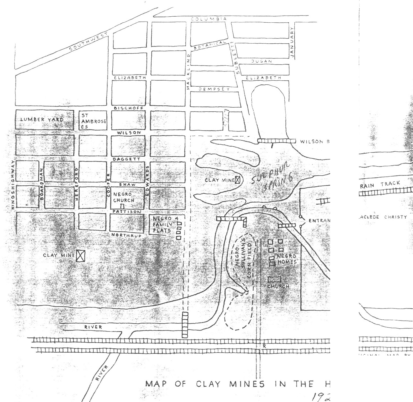
It seems that a resident of the hill, Mario Torretta, drew a map of the area of Sulphur Springs as he remembered it in 1923. See map below.
The map, of which I only have a xeroxed copy, must have spanned two pages and what I have has a gap between the left hand page and the right hand page. I have put it together as best I could. Below the photo is some orientation to the map.

At the bottom of the map you will see the two railroad tracks, Missouri Pacific and Frisco. The very bottom would be where Manchester Ave. is.
Note that the large sulphur springs lake would cover the whole of what is today Berra Park.
The street which runs north/south to the LEFT of the lake is Macklind. The partial street which runs alongside of the "Negro homes and corn field" would be January.
Mario Torretta also gives a vivid description of what it was like to work in the mines:
Well, you see, first there was coal mining here. Some of the places - I remember in my early days you could tell certain places where they had a shaft, where they went down
. . . You can't see that everywhere today, because everything is improved and leveled off. There's a lot of fireclay. Right across from here, the company I worked for, I was under all of this here, sixty feet deep. We used to go down in the mine. For over forty years they took that clay out of there. Did you ever see fire clay - how it looks? It looks like soap stone, kind of bluish clay - they make these fire-clay brick, which is not a building brick. They line these furnaces in these foundries and the locomotive furnaces; it a a high-grade material that will stand a lot of heat. These glass furnaces. Itís not a building brick. That's all they made where l worked. They manufactured that firebrick. From Manchester all the way up to Arsenal Street and from here over to Hampton Avenue -- that's all undermined. We had to go down there, and they always had two pumps working day and night. The water was coming in there all the time. If they wouldnít pump it out, they would get drowned out and couldnít work in the mines. We had to go down and take care of those pumps. That was awful valuable stuff. There were several other mines around here, too. Thatís where a lot of these men made their living. They got to get the clay out and then they would grind it and pulverize it, rub it over a screen and then it goes through the machine and they mix it. Then it goes through the press and the driers and then they burn it. It was quite an interesting piece of work. Theyíve been there for about 125 years, that company. And years ago they got that land for nothing. But they finally did run out, and later on they had to ship it in my railroad. Theyíre gone all together now, hou know; theyíre out of business. The highway went through here. It looks like nothing happened there. Many a hoard dayís work went in there , Iíll tell you. We had three shifts going. They didnít care if you brought your bed down there, because the machinery was running day and night. We couldnít hardly keep things together. Itís wear out so fast. It was our place to keep the things running, you know. The government took everything you could produce. I got away from there. Itíll soon be twenty-two years since Iíve been away from that. (H Ė 12).
Source: Map of Clay Mines In The Hill 1923. Original map by Mario Torretta. This map presented is an adaptation.
| HOME | DOGTOWN |
| Bibliography | Oral history | Recorded history | Photos |
| YOUR page | External links | Walking Tour |