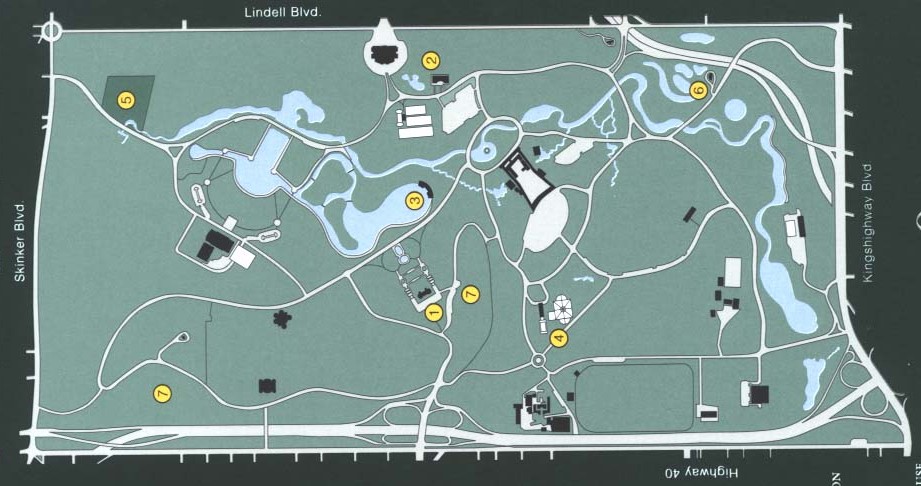
Below is a scan of a drawing from a document of the Forest Park Forever group's brochure. Please take a look at the photo and then see the comments below it.

Some comments on this idealization.
- The new water-way or river system will begin at the northwest corner of the park, where the old waterfall is. That's at # 5 on the drawing, in the upper left corner.
- While it certainly isn't clear to the naked eye, I am told that the level of ground is such that water will flow from that point all to way to the Jefferson Lake over by Barnes Hospital or The Planatarium in the southeast part of the park.
- Note that at the waterfall, the "river" will immediately cross the street to the golf course side, north side, of Lagoon Drive. I am told there will be a bridge over the river at that initial spot.
- The river then runs east along the southside of the golf course, but the question is: Where does it tie into the new center piece of the waterways: Grand Basin. That's not been made clear to me. Note that along Lagoon Drive there appears to be a modestly large part of the north end of the new Grand Basin which extends across Lagoon Drive and onto the golf course. However, the drawing shows not "connection" there, no bridge. It would seem that will need to be a connection, maybe not.
- The "river" part runs along the golf course, and then crosses over behind the Dwight Davis tennis courts and runs to the front of the Muny Opera. When I was there on last Sunday I rode up to where there used to be an old bridge when the road from Hampton which ran through the park used to go straight out to Lindell from the zoo. Right where that bridge was at the northern end of The Post-Dispatch Lake, it seems like there is a "connection" being dug where the river ties into the Post-Dispatch Lake and would have access to the Grand Basin. However, that would be quite a round-about route.
- I know for sure that the river system continues on east past the Muny Opera. However, if you go over and see the current finished park in that circle in front of the Muny -- where the bandstand is in the middle (which, by the way, is a startlingly beautiful finished piece), it is not clear how this will continue on east as "river." Right now there is a sort of rock falls there that would have to be removed if the river is to run through.
- Once past the Muny, the river runs through a newly cut channel along what used to be a cricket field, and then turns sharply south near the Union Ave. exit, and runs past all those small lakes that were fish hatcheries in the past, and ends at Steinburg Skating Rink.
- This particular map shows the river running all the way into Jefferson Lake itself, but I have been told recently that it will end at Steinberg, just west across the street from Steinberg. But, this part is not clear.
- Along this entire river system will be two different trails, one for bikers and skaters, another for runners and walkers.
- Right now (July 25, 2002) much of this is in construction and quite a mess. But, small stretches, particularly in the area of the Muny Opera, are finished and give one a look at what it's going to look like. There aren't enough superlatives to describe that. If you haven't been over that way lately I urge you to go. It is really lovely.
| HOME | DOGTOWN |
| Bibliography | Oral history | Recorded history | Photos |
| YOUR page | External links | Walking Tour |