Contents
THE BUSINESS AREA OF MANCHESTER
THE WEST END HEIGHTS AMUSEMENT CENTER
MAPLEWOOD CONGREGATIONAL CHURCH
WEST CHELTENHAM
As noted partly from the book "St. Louis: and its Neighbors, Landmarks and Milestones"
This area is, I think, west of Tamm Avenue. Of course, I can’t prove this. The boundaries include the streets; Berthold, Tamm, River Des Peres, and The City Limits. Anyone can prove me wrong.
It is very hard to find a map earlier than 1850. I have a copy of a sort of professional map that shows the large plots of land, evidently showing the break-up of the Gratiot legacy.
Figure 1. West Cheltenham
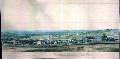
The paper with it identifies this as “West Cheltenham” St. Louis #399” Also: Roll 900 Frame22
It
sure pays to look a little closer. So I’m not sure if I took a picture of the
original or a copy. There must be a way to see the rest of the collection of “Outside
St. Louis”.
A note from Bob Corbett found that the Dogtown Historical Society
has enlarged copies framed. This was as of Jan.6, 2004
WEST CHELTENHAM MINES
"GITTEN'S MINE" (CLAY) BETWEEN CLAYTON AND BERTHOLD; JUST WEST OF TAMM IN 1914-1917-.
"HIGHLANDS #4 MINE" (CLAY) AT LOUISVILLE, WEST PARK, KRAFT, AND VILLA IN -1937-.
"MISSOURI FIRE BRICK MINE" (COAL?/CLAY) AT KRAFT AND DALE DATE UNKNOWN.
"GRANDVIEW FIRE CLAY-VAN CLEAVE MINE" (CLAY) AT DALE NEAR LOUISVILLE IN -1909-1911-.
"MISSOURI FIRE CLAY MINE" (CLAY) AT LOUISVILLE; NORTH OF DALE IN -1911-.
"CHELTENHAM CLAY COMPANY MINE" (CLAY) AT HILL ROAD (MITCHELL) AND FOREST. IN -1916-.
(THIS MINE MAY BE A BLOCK NORTH AT PLATEAU WHICH USED TO BE NAMED HILL ROAD).
Old-Timers say there was a mine on the north-east corner of Cutter and Plateau or somewhere between Dale and the present Plateau. (The original name of Plateau was “Hill Road”). Old maps show Mitchell didn’t exist from Prather to McCausland early on.
"GILKER FIRE CLAY MINE" (CLAY) NORTH-WEST CORNER OF MANCHESTER AND McCAUSLAND IN -1896-.
"MATTHIESON AND HEGELER MINE" (CLAY) N/W CORNER OF FOREST AND MANCHESTER FROM 1863-1896-.
"CLAY FACTORY IN WEST CHELTENHAM"
"BROCKSCHMIDT BROTHERS" BETWEEN DALE AND TAMM, JUST NORTH OF MANCHESTER.
An 1878 map shows MATHISON HEGLER ZINC CO. on 5acres on the east side of Valley Road, bordering north of the Muegges.
Figure 2. Map of Benton
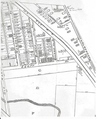 |
I never really found the boundary of Benton. It is mentioned several times.
The Roe School used to have the “Benton Library”.
Then there was a “Benton Station in 1853/54 at the Pacific R.R. tracks and Ecoff.
Then in 1870, the Benton Station School at McCausland and Manchester. This was the second school in Cheltenham. This name carried on when the school was moved up the hill to Mitchell, west of Prather. The name was then changed to Roe School.
Erhart Franz moved to “Benton” in 1871 on Hill Road (Mitchell Road). He had large Real Estate holdings in “Benton”.
The United Methodist Church was organized in 1888, in the area called “Benton” at Forest and Bruno, later moved to McCausland and Stanley.
These are the few indications of “Benton”, but no definite boundaries. I am guessing “Benton” went from Glades to Old Manchester (Southwest), and Kraft to McCausland. This followed the old property lines of John Pierre Gratiot.
Or it could have included the Glades on the old property of Henry Gratiot.
Figure 3. Benton School
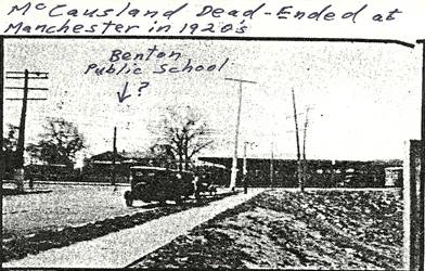 |
Some day we will know.
As the area west of Cheltenham was growing, “Benton Station School” was opened in 1870 on Manchester Road near the Benton Station on the Pacific R.R. at Ecoff. The school was located on the S/E corner of Manchester and McCausland. It was similar in appearance to the Cheltenham School, although it’s two rooms could only accommodate 90 students.
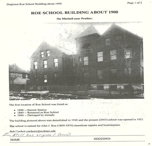
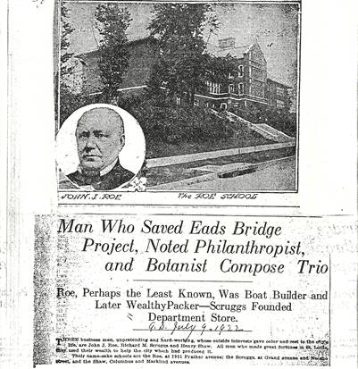
Figure 4. Roe School
 |
The school had a wide reach in the early days. Richmond Heights’ history stated that Nieson’s children rode to Benton Station School on ponies until Bartold Station School opened in Maplewood.
By Oct. 1888 an eight room (six classroom) school was built at 6828 or 6830 Mitchell (then called Plateau Street). Actually, Mitchell, in the early days, was called “Hill Road”. This included a turn at Prather to what is now Plateau. The new school was still referred to as The Benton Station School in the St. Louis Board Of Education annual report for 1887/88. However, in the Annual Report for 1888/89, it was called “Roe School”. The old school was evidently there when I was young, but for the life of me can’t remember it. I do remember playing marbles in the squares where the large cottonwoods grew. I didn’t grow as well as they did. My older friends and neighbors remember seeing it, and I should have too. Don’t think it was torn down until 1940. I did eventually find the 1899 plat map which showed the outline of it. Then just before I left town, I found the whole load of pictures at Gratiot School, of class pictures and one of the old school. It cost to have it reproduced from the negative, but at least I have it now.
Note: Not sure if the old Gratiot School is open. It was like an old museum. Kind of sorry I left my high school yearbooks there.
According to a Jewel Hutchings Robinson, by 1910 Roe school was too small, and portable buildings and an old farm house were used as classrooms. The farmhouse was used for Kindergarten, and was used for graduations. Not sure which house this was. My good old 1899 plat map shows two houses on the south side of Mitchell. One was a two story frame at 6838/40 Mitchell, a 145 ft. wide lot, from Forest to – (possibly the I. Urig home of 2.16 acres/1878.). The other, a two story frame at about 6818 Mitchell with a 93x235 ft lot. (possibly the E. Wider home in 1878 of 4.52 acres).
Figure 5. John Roe
By 1921 a thirteen room school was finished on the lot previously owned by E. Wider at 1921 Prather. (kismet). A few years later (1927) a six room wing was added to the north side. Currently, or at the time I originally wrote this, the school was used for kindergarten to sixth grade. About 75 to 100 pupils were foreign students, and about 50% were black. The rest were locals. Sometime in the 1990’s a gymnasium was added on the southwest side.
John J. Roe the namesake of Roe School was a boat builder who started trading in boats and became very wealthy. He used his wealth to help the city which had helped produce it. When he retired, he came to St. Louis. Instead of resting, he started a meat packing business, and had interests in many ventures. He saved many firms, helped young men trying to make it in business. One of his greatest achievements was to save the Eads Bridge. The builders ran out of money, and he thought it was so important to St. Louis that he personally donated $100,000, then went to the east coast to promote the bridge and drummed up $1,000,000.
During the Civil War he furnished supplies to the U.S. military, working with Francis Whittaker. This was when the government had neither cash nor credit with which to make purchases. His life was more active after than before retirement. He died at a meeting of the directors of the Memphis Packing Co. on Feb.14, 1870. His death was so great a loss to the city, the Mayor ordered business suspended on the day of his funeral, so the whole city could do him honor.
Never did see the name of his wife, just that he married the daughter of Thomas Wright of Cincinnati in 1837. Their home stood at the corner of Lafayette and Compton on ten acres, a beautiful estate.
THE PRATHER ESTATE
In the 1850’s, the large “Prather Estate” went from Tamm, to McCausland, and on the north, on a line with Glades. On the south side, on a line with Bruno (?) As I re-type this, I see where my past research was a bit flawed. It occurs to me Prather’s Estate wasn’t as large as I thought. The usual little arrows that connect areas are not there. His land looks as though it stopped at Manchester. The land to the south of Manchester and the tracks was owned by Peter Bambrick. (24acres), although he could have bought it from Prather. This land would be the future site of Scullins Steel Company and other Steel Foundaries all the way to Southwest Avenue.
Figure 6. The Prather Estate
By 1878, Webster M. Samuels owned approx. 18acres from Glades to Manchester, and from Prather to Kraft. He also probably bought from Prather.
As another correction, Johanna Muegge may have bought from Prather. Not where I first thought. This was a little over 1 acre south of the tracks in a bend of River Des Peres. This is probably where she had a picnic ground. Maybe this was in connection with Sulphur Springs.
By 1899, the area south of Glades from Kraft to the City Limits was highly populated. I think a lot of the old two story frames in this area are showing their age, especially around Glades and Garner. This could have been “Benton”. I must do more research on James Prather. It seems he was a Priest or a teacher. I faintly remember reading about him owning property when he shouldn’t have.
ST. LOUIS PERFUME COMPANY
Figure 7. St. Louis Perfume Company
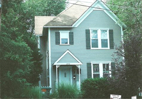
This is all I have. This was the Sizemore home on Glades. The factory was behind it. The section of roof in the rear appears to be attached to the house, but could be the old powder house behind the house. The main factory building was off to the right rear. Surely, there is a good picture somewhere. The address is 6746 Glades.
The information for this company was found in a Gateway Heritage Magazine (Spring 1982).
This is about the only production plant in Prather’s old estate.
Many St. Louisans will remember the labels and cartons portraying the St. Louis Perfume Co; Doray, Dirgo, Cal-A-Pax, Nancy Kay, Mareschal-Neil, Salko, or half a dozen others. All made in the same St. Louis laboratory, and conceived and mixed by the same chemist; Dr. Clarence R. Sizemore.
He was born in Erin, Houston County, Tenn. on Oct.27, 1868. His father, Dr. R. H. Sizemore served as a field surgeon in the army of the Confederacy and maintained his medical practice until his death when his son was 10 years old.
Clarence became a clerk in a drug store. Then from 1887 to 1888 he attended Vanderbilt University in Nashville, studying Pharmacy. He went back to work in the drug store, then bought it. A short time later he sold the store and went to work in Henderson, Kentucky. From there he worked in Memphis, Tennessee. He contracted Typhoid Fever and went back home to Erin to recover. He then traveled to Dickson, Tenn. and founded the Dickson Drug Company. During his seven years there he obtained his doctoral degree in Optics.
His first job in St. Louis was with Pullen-Richardson Chemical Company, and he lived at 3106 Lucas. He soon moved into the company at 219 Chestnut. While he worked there in 1908, he served briefly as Vice President of the Missouri Box and Label Company, learning packaging.
In 1911, after obtaining an alcohol permit, he established the Carnation Toilet Company, manufacturing chemicals at 3156 Easton. He took on a partner and continued to work for Pullen-Richardson. In 1913 this company was absorbed by Allen-Pfeiffer Chemical Company. He went to work for this company, and after four years he became General Superintendent, Chief Chemist, and Buyer.
After a year he went to The American Drug Company. Where in 1921 he was made Chief Chemist. While there he promoted an arrangement between American Drug Co., moving into the building of Allen-Pfeiffer, working separately, but sharing the laboratory. Sizemore supervised this combined laboratory.
In 1925 he did what he always wanted, starting his own firm “St. Louis Perfume Co” picking up two partners with money; C.F. AND John Van Dale, with a capitalization of $10,000. They manufactured their own product, and also for other firms at his home at 6746 Glades Ave. By 1927 he bought out the Van Dales. He then worked with his wife Rose.
The Great Depression brought on hard times and new partners; Windorf H.Walgren and Jeremiah A.Wiedknecht in 1931, both residents of St. Louis. They incorporated the St. Louis Perfume Company with $28,000.
Writing in 1934, Sizemore called it “An unfortunate alliance and quite a setback to the business”. He had to develop new products, and more companies. At that time he built a new building next to his home at 6748 Glades.
In 1935/36 he tried printing his own labels by installing a printing press in a small building behind his house. By 1939 at the end of the depression he was in his 60’s with heart trouble.
WW11 almost brought him the success he was looking for, but he died of Pneumonia on Dec.29, 1943. After his death, his wife sold the company and moved to an apartment on Lindell. The company remained open until the 50’s, but the factory building is now gone.
My mother and aunt worked there, and I cut grass for a spell. The old house still stands, was rehabbed and is looking good. My uncle rented the house after the war, but we all just cleaned up the inside and repainted. I remember painting the banister for the steps. I suppose that ruined the beautiful mahogany. We were sure glad that job was over. The rehabbers have done a beautiful job.
A small bungalow is next to the old house on what I think is the old property on the west side of the big house. I can remember the old factory with the wooden floors that creaked, the big mixing vats, and the sweet smell. The old factory was full of mysteries and the house was a quaint old place. The only bad thing was the powder building where my mom worked sifting powder. I don’t believe this helped her health at all. My aunt was the secretary for many years. The old men that worked there would sit out in the shade during lunch break, and I can remember Charlie Lagarce could sit with his legs crossed on the ground and get up without any hand help. He also could jump up on a table from standing flat footed.
The factory is just a memory, with new houses being built on the rear property.
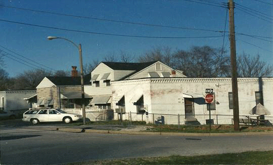
THE BUSINESS AREA OF MANCHESTER
One other thing that almost slipped by me was an old car shed on Manchester, between Kraft and Waldemar. I finally found the old car shed on an 1899 Plat Map.
For the life of me, I don’t recall this. So it had to be old. Think that is R/R at the bottom. No street car tracks.
Figure 8. Sanborn Map-Business Area
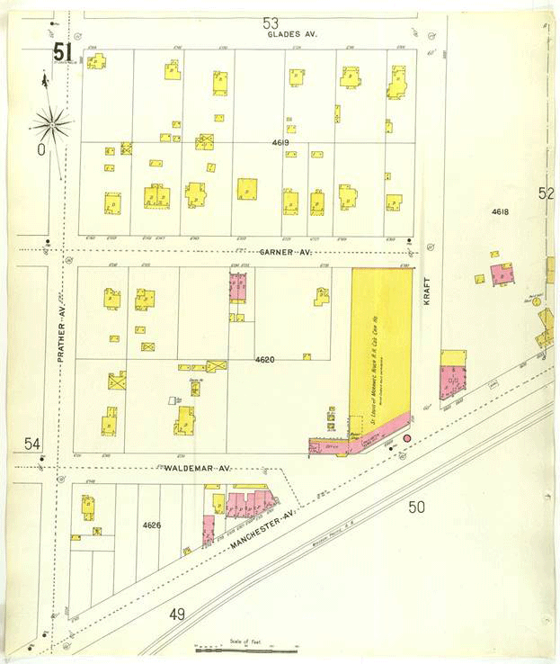 |
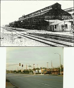
Figure 9. Scullin Steel Co.
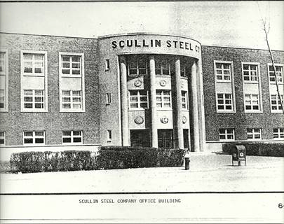
I can picture this building tucked into the steep hill at Kraft and Manchester. It took a long time to find an old map showing this “not so old” Scullin Steel Office Building which is now “Copying Concepts”.
I can almost remember this building as a child. It could have been there in the 1940’s. Of course, since I had to walk down Prather and Waldemar to catch the Manchester Streetcar, I was usually in a hurry and didn’t pay much attention.
The places I remember most are: the small confectionery at Prather and Glades, Faloni’s Bar, The Coal Company at Manchester and Prather, and the old restaurant on Waldemar off Manchester which was a rip-roaring place. The men from Scullins Steel ate there. The blacks had to eat in the back kitchen. It was the loudest place I had ever seen. And of course, I remember the main gate of Scullins on Manchester at Waldemar where the women waited for their husbands to get off work with their pay checks.
Figure 10. The Old Feed Store
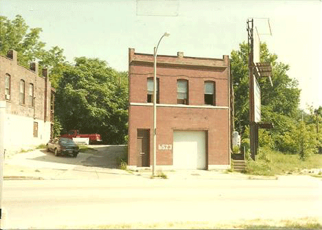
I have taken a picture of what I think is the old Feed Store on Manchester (6523). I can remember as a child walking to the feed store. It was just west of Mitchell. It has just recently been torn down. (Summer of 1999). West on Manchester, was the Ice House just west of McCausland. This was a great place to ride your bike to refresh.
THE GLADES
Figure 11. Ringrose D. Watson
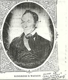
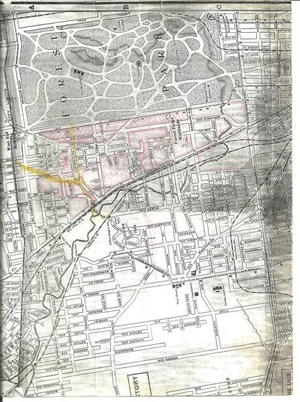
The Glades is a section of Gratiot League Square owned by Ringrose D. Watson. He was a land speculator, at least with The Glades. The boundaries of the Glades was Tamm, McCausland, on a line with Dale and on a line with Glades. I’m not so sure of the McCausland boundary, since an 1878 map may carry it to Big Bend.
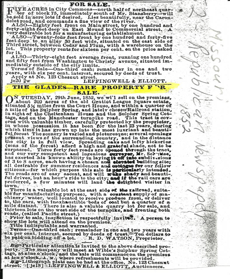
This would match Henry Gratiot’s inheritance. I also found a page of the old Missouri Republican Newspaper of 1852, which had an advertisement of property for sale. 200 acres of subdivided lots belonging to Ringrose D. Watson (for 25 years) since 1829.
Figure 12. 1852 Newspaper Article
 |
Since I wrote this, I found deeds that reference the “Glade” family. It’s quite possible the 1829 date may refer to those “Glades”. Watson may have bought from Glades. I also read that the Glades owned a farm at Kraft and Dale. Their home was on the west side of Kraft, about where Dale intersects it. (Not sure where I found this).
It’s hard to find a good map dated before 1850. At least this gives more meaning to the story.
In my original story, the Glades was covered with valuable timber, a beautiful place with a great view. Many could see the city (which may mean to Grand which was the city limits at that time). It had Valley Road (Dale) winding its way to McCausland with 500 Ft. hills on both sides. On the north, to Hi-Point, and on the south, to Hill Road (Mitchell). This hill can be seen on a contour map. It runs all the way from St. Mary’s Hospital to Mitchell, and on down to Manchester.
Two branches of a creek ran through the valley. One from a spring at the grounds of St. Mary’s Hospital, across McCausland along the north side of Dale and crossing to the south side and joining the other branch. This other branch started somewhere on the north side of Clayton from another spring.
Figure 13. Map of the Glades
 |
This spring ran down the east side of Louisville. Both then went down to River Des Peres, or later filled the quarry at Manchester.
There was a rock quarry at the N/E corner of Mitchell and Manchester owned by David O’Gorman from about 1850 to 1867. He sold this to Richard Hanrahan. An 1878 map shows R. Hanrahan on approx. eight acres bordered by Valley Road, Manchester Road, Hill Road, and on a line with what is now Sanford. I was told to stay away from it and did. It was so very deep. I can’t remember it being filled in, but a city junk yard sits on top of it now.
During the World’s Fair there was a railroad spur from the Pacific Railroad. The tracks either went on Dale to Sanford, or were on the side by the quarry. I have taken pictures of this area also. This has been verified by Bob Corbett, and some R.R. historians. A map from 1904 shows two tracks coming from both the Pacific, and Frisco tracks. The map shows the tracks closer to Mitchell. On the other end at the park, lines appear to show an overpass, or an underpass. Today, you can see how the area has not really changed that much. You just have to picture in your mind, a bridge on Clayton Road, just east of Louisville. And less some landfill, the hill would not be too steep for a train. It has been fun to see the story of the train develop.
One other thing: Take note of the River Des Peres south of the tracks. I have always wondered how it all came together. This map doesn’t help.
Figure 14. Map - Train to the Fair
 |
Now, back to Manchester, east of Mitchell. There is a tavern on the N/E corner, and a city tow lot from there almost to Dale. This is right on top of the old quarry. On the N/W corner, another tow lot has been cleared, and now storage buildings are growing.
On a painting by Albert Muegge, you can see a house on the inside bend of Mitchell, and houses on what should be Dale. Albert had painted this and other paintings in the 1870’s, with a memory of the 1850’s. The painting showed houses in the background, which would be about at Kraft.
The 1878 map shows on the south side of Mitchell a “M.V. Steigers” with 4.23 acres on that inside bend. Following the south side of Mitchell all the way to McCausland, “John Goebel” with 5.28 acres. Next, Henry Kleinschmidt east of Kraft with 1.39 acres, and F.T. Kleinschmidt west of Kraft with 1.33 acres. Next, E.D. Franz with 5.52 acres. West of Prather, E. Wider with 4.52 acres, then I. Urig with 2.16 acres. These last two are now Roe School. After that, “Stanislaus Mitchell” with 6.61 acres which went to McCausland. His house, the only one shown in the whole of “The Glades”. The address was 6926 Mitchell. There are no houses on Mitchell now, so I think the house would have been on the S/E corner of Mitchell and Mitchell Place.
The only other thing I will have to add is the Clay Mines of the Glades. There is very little info on who owned what. Stanislaus Mitchell, who lived on Mitchell owned a factory on Manchester, and probably most of the clay mines in The Glades, at least in 1900’s. Not sure about this man. This is all I know.
Stanislaus Mitchell lived on 6.61 acres from Forest to McCausland, and Mitchell to Glades. His house stood at what is now 6926 Mitchell. He was the president of Mitchell Clay Manufacturing Co. at 5625 Manchester which started in 1857. This was between Sublette and Pierce on the north side of Manchester. They had clay pits at the factory, also a mine at Pierce and Victoria. I also noticed his name written across property north of Dale and west of Kraft, which was probably clay mines.
FRANZ PARK
Figure 15. Ehrhardt D. Franz
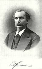
“Franz Park” was named after Ehrhardt D. Franz, a merchant who sailed for the U.S. in 1854 at the age of 21. He became interested in merchandizing in Albuquerque, New Mex. Freighting goods across the plains to the towns and military posts. In 1871 he moved his family to St. Louis, residing for a few years at Webster Station, then moved to Benton Station. (This helps me to extend Benton up to Mitchell, I think). He retired from the grocery business in 1873, but didn’t really quit until 1895. He was a stockholder in the Third National Bank, had large real estate holdings. From dealing with Indians to selling retail drugs, food, and hardware, to just plain making money, this was his life.
Their home, as far as I can see, was at 6730 Mitchell on what is now a tennis court in Franz Park. Ehrhardt died February 7, 1898. Their homestead was 4.6 acres, and many tried to buy it, but for a long time the family desired it to be donated to the City for a playground for the children. I suppose it may have been in the deed, the land had to be used for a playground. The developers never did get it.
Figure 16. Newspaper Article-Mrs. Sophie Franz
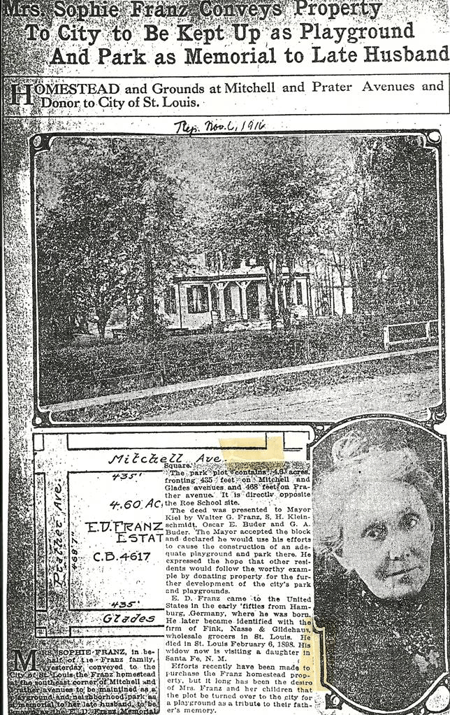
Finally on November 6, 1916 the land was turned over to Mayor Kiel by Walter G. Franz, S.H. Kleinschmidt, Oscar E. Buder, and G.A. Buder, in the name of Sophia Franz who had moved back to Santa Fe, New Mexico. The land was donated as a tribute to Ehrhardt Franzs’ memory.
Ehrhardt was survived by 10 children, and 9 grandchildren. Also by the thousands of children, who through the years who have enjoyed the park.
Figure 17. Franz Park - 2004
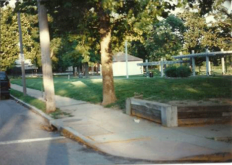
Since I wrote this, there has been some discussion about the park. So, I’ll tell what I remember. I still picture the steps into the park at Mitchell and Prather. There was a little worn spot alongside the steps where you could jump the curb with your bike, then run right up the side of the steps. Of course you would be in trouble if you rode your bike too far into the park. The walkway went at an angle to the shelter, then back at an angle to the east side of the park.
On the south side of the building were a few steps to the pool. We always tried to run on the raised edge of the pool, then got chased. The pool must have been drained daily, but can’t swear to that. It had to be drained sometime because there was no circulating pure water. Whatever went into the pool stayed there till it was drained. So I didn’t swim. Spent many an hour playing handball in the middle of the shelter (double wall). Played ball down the hill whenever there were enough players, which was seldom, because it got so hot down there.
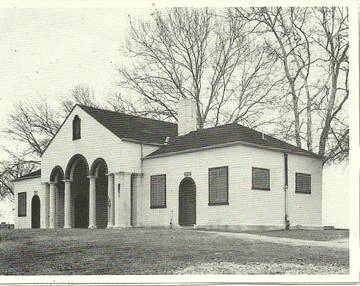
A walkway went around the edge of the hill above the ball field, and was joined by another path from the building to Prather and the ball park. I do not have a picture of the park, but have a picture of a building that was identical to the one at Franz. I believe the new building is in the same spot as the old one, and horseshoe pits are where the old pool was.
When I was young, you had to take turns with the swings and the seesaws. Some ornery old men would tie them up on occasion. Suppose that happened when things got out of hand or just certain times of the day. The favorite ride was the circle swings where only the older and bigger kids got to ride. They were dangerous in a way because they went fast especially with the game of hanging on with one hand and reaching for little sticks on the ground.
As older youth we turned to horse shoes on the east side of the park. Now the tennis courts take up the area of the circle swings and horse shoes.
After the park closed, the older boys would head for the drugstore at Mitchell and McCausland and just hang around in front and tell jokes. That was until Mr. Jones (?) had us move away from the front of the store. So we moved across the street to sit on the wall on the north side of Mitchell.
As we grew we spread out to play basketball in the school yard, then later days started on cork ball where I threw my arm away. That was my youth around Franz Park, and they were good days.
Figure 18. Building at Franz Park
If anyone sees the park differently, have at it. My memory isn’t the greatest. Surely, someone has pictures or since it is a city park, there should be records. Especially from the day it was presented to the city, personally to Mayor Kiel in a ceremony that would require photos
Sophia D. Franz gave her 5.32 acres to the city in 1915, with a stipulation it could only be used for a park and playground. This was in honor of her husband Ehrhardt D. Franz.
Ehrhardt was a wholesale merchandiser. He came to the United States in 1854, and after accumulating some wealth, moved his family to St. Louis (Benton) in 1871. Their house sat on 6730 Mitchell, approximately where the tennis courts are now in the park.
He had large real estate holdings in the vicinity of Benton. He retired in 1873, but went back to work in 1880 in the grocery business until his store burned down. He then took care of his property interests until he died in 1898 at 65.
As a side note, one of the persons presenting the deed of the property to the city was S.H. Kleinschmidt. The Franz’s daughter Minnie married Sherman Kleinschmidt. They were old property owners living just down the street from the Franz’s
And I’m guessing they were in mining.
THE NORTH SIDE OF MITCHELL
I might add as I rewrite this chapter that the north side of Mitchell hasn’t been covered at all. There were many large houses that are at least 100 years old. The whole area from the top of the hill down to Manchester was well populated with large houses. This could well be my lost area of Benton.
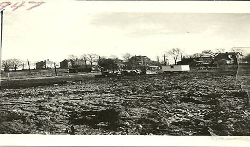
The picture below shows the homes on Mitchell. This leveled land is bordered by Kraft, Plateau, and Brock over old dump and clay mine. This was being developed after WWII.
Figure 19. The Homes on Mitchell
THE WEST END HEIGHTS AMUSEMENT CENTER
The streetcar also brought this Amusement Center, which didn’t last long. My favorite method of research, map hunting found this (From a 1905 plat map). West End Heights was an area, approximately from Hi-Point on the east, Wise on the south, City Limits on the west, and Clayton Rd. on the north. From later info, it seems to have been a kind of Picnic/Campground area with a lot of trees. As of this date (Sept.2004) this was verified by an advertisement for 100 tent hotel set up there for the World’s Fair.
There is more on this area in my research of Richmond Heights. I remember a Post Office and a small Commercial District just inside the City Limits. Not sure of the name of the Post Office. (Need more research) There is no definite location of the Amusement Center, but would seem likely to front at Hi-Point. This Amusement Center burned in 1913. The land was offered to the city as an entrance to Forest Park, but the city ignored the offer. The owners withdrew the offer and sold to the Pierce Oil Company in 1922.
By 1926, the Hi-Point corner already contained a movie theater, and two gas stations. One of the stations stood on a triangle of land that had a very large sign. This sign used the old light bulbs, and was replaced with a more modern one using florescent lights or something. The Hi-Point Theater and the Cheshire Inn are now on the south corner of in this intersection.
The city must have finally decided they needed an entrance to the park there, and after many years the entrance is just to the north of Hi-Point. The farmers from Clayton and Richmond Heights had this route through the park way back in the 1870’s. It took a long time to see a good thing. They were only interested in stopping the heavy traffic through their beautiful park. Guess it all was for the best. They must have changed their route to Clayton Road, and through Dogtown, and thus helped Dogtown to grow. Where would Dogtown be if there was no Clayton Road?
TAMM AND MANCHESTER
The Missouri Historical Society Bulletin, Vol. XX11, stated the address of the Muegge home as 6229 Manchester at Dale (Valley Road). It should be 6429 Manchester since 6400 starts at Tamm. The home was on a lot 100 x 205Ft. An alley went from Tamm, behind the Muegge Home at Dale, then to Mitchell. I think there was a Brockschmidt Brick Company located on Dale and this alley. Later, there was another small plant which I can’t remember.
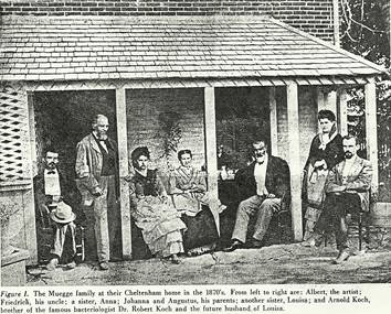
Figure 20. The Muegge Family Photo
Also, the exact location of the O’Gorman home which is said to be the first house on Tamm (Per the history of St. James and Cheltenham) was later found to be 1527 Tamm.
The 1878 map shows John O’Gorman next door, east of Muegges. His lot fronting on the S/W corner of Brockschmidt and Tamm. The 1899 plat map shows an unmarked two story house on the south side of 1527, which usually means the house was remembered but did not exist in 1899.
On the N/W corner of Tamm and Manchester is the Cooper Tire Company. This was previously “Dolan Company” and before that “Clifton Heights House”, which was started as a tavern in 1894. People started borrowing money, so John P. Dolan started a Loan Co. in a small back room of the tavern in 1908. John Dolan and Thomas O’Gorman opened the Dolan Realty Co.at 6403 Manchester in 1909. Then by 1928 the building was remodeled for a loan company without a tavern.
The 1878 map shows empty lots between Manchester and an alley from Tamm to Hill Road. This must have been part of the rock quarry or just a large front yard for the Muegge’s and O’Gorman’s. There is something wrong here. (The location of Brockschmidt St.).
In 1867, the Lancasters lived 100 Ft. north of Dolans corner. Later this piece of ground became the property of the Nixon’s.
Also in 1867, a picnic grounds was across Manchester from Dolan’s Real Estate office, east of which was Peter Hume’s farm. Mr. Hume was the father of Mrs. Ed Nixon.
There were a few small houses on the right of way of the MO/PAC tracks. One of these, at Dale was owned by John Conners. Andrew Cahill lived near the tracks east of Tamm.
There is a hint of this area being called “North Clifton Heights”. I have a membership card for J. W. Ode for the “North Clifton Heights Improvement Association”. It isn’t dated. The return address is 6333 Clayton Avenue.
THE MUEGGE STORE
The Muegges moved to Cheltenham in the early 1850’s. Augustus entered the grocery business in 1850, according to the Missouri Historical Society Bulletin. This was on the N/W corner of Dale and Manchester.
By 1852, Cheltenham had enough people to establish a Post Office in the store. The old two story brick building still stood in 1937. As a side note: General Grant, when coming to St. Louis from Grants Farm, often wassailed in Muegge’s store.
Johanna Muegge also had a small corner. (.5acre) on the south side of Manchester. This piece of land would fall in line with the Glades. Johanna was the wife of Augustus, who must have died in the 1870’s. I read somewhere this small piece of land was used as a small park or picnic ground.
The store and Post Office were on the ground floor of their home. I have a copy of a picture (Figure 20), of the Muegge family which includes their son Albert the artist.
He painted several good pictures of Cheltenham, (Some painted, by memory in 1877 of 1856 scenes). See http://faculty.webster.edu/corbetre/dogtown/people/muegge-paintings.html
Some of the paintings are in the Missouri Historical Society Library, and there are some pictures printed in the Mo. Hist. Bulletin. For some reason, earlier (while writing these chapters) we could not copy these into our web page. It was not as though we are going to make money on them. This was a set of eight pictures, or so stated in the bulletin. Have not found numbers 3, 5, and 7. Early on, I got permission to photograph a few of them. But it seems the door was shut for some reason. I took the pictures without flash, because they didn’t want too much light on them which seems reasonable. It would be great to have them on the web. I also have taken a rough panoramic view of the area. This was from the south side of I44 at the turn-around of Tamm. You can reach this spot by way of Southwest Avenue.
There is another picture (painting) by Alfred Muegge, drawn from a position east of Tamm. It shows a small factory with a fence line behind it, which would be Tamm in the future. In the background was the Muegge home. This seems to be a painting. The location of this Factory seems to be on the N/E CORNER OF Manchester and Tamm. The name being “The Cheltenham Oil-Cloth and Window Shade Factory” as it appeared in 1854.It could have been a forerunner of the intense industrialization of the area.
Later, I found an advertisement of “F. & A.MUEGGE’S Oil Cloth and Window Blind Manufactory”
They also made waterproof cloaks, coats and wagon covers. The address being No.173 N. Second Street. Could it be they had their factory in Cheltenham? This is the same corner where, in later days, the Cheltenham Fire Brick Co was located.
In 1934, the Tamm-Dale Market was operated by Frank Baretich at 6413 Manchester. This must have been a little closer to Tamm. Muegges was 6429.
TECH Electronics is on both the N/E and N/W corners of Dale and Manchester now, with a shady grass lot on the N/E corner.
SCHOOLS OF WEST CHELTENHAM
As the area west of Cheltenham was growing, a school “Benton Station School” was opened in 1870 on Manchester Rd. near the Benton Station on the Mo/Pac RR. It was similar to the Cheltenham School, although it’s two rooms could only accommodate 90 students. I think this school was approximately where McCausland intersects with Manchester. McCausland stopped at Manchester until sometime in the 1920’s.
I have found new evidence this school served what is now parts of Maplewood and Richmond Heights in the 1870’s. Since the City Limits stopped at Grand, this whole area was considered the County.
After the separation of the City from the County in 1876, Maplewood opened a school in a two story frame building on Comfort Ave. west of Big Bend. This was in February or March 1877. This served Maplewood and Richmond Heights until they moved to Bartolds Grove in 1878 (Valley School). In 1905 Richmond Heights asked for their own school.
Benton School also outgrew itself. By October 1888 an eight room (six classrooms) school was built at 6828 or 30 Mitchell Avenue. It was still referred to as the “Benton School” in the St. Louis Board of Education annual report for 1887/88. However, in the annual report for 1888/89, it was called “Roe School”.
Many old timers remember the eight room school building, and when it was torn down. I must have been too young. My older brother remembers it, so I said “draw It”. For a long time, the best I could do was find the 1899 plat map with an outline of the school shown. Then, a visit to the Archives Department in the old Gratiot School on Hampton produced a great picture of the old eight room Roe School on Mitchell. My search is over.
According to Jewel Hutchings Robinson, by 1910 the school was too small. Portable buildings and an old farm house were used as classrooms. The farm house was used for Kindergarten and was used for graduations. Don’t know where the farm house was, but there was a large frame house right next door to the east. It shows on the picture of the school.
My good old 1899 plat map shows two houses on what is now the school grounds. One was a two story frame at 6838/40 Mitchell. A145 ft. lot from Forest to what may be the alley, and from Mitchell to what is now Glades. (Possibly the I. Urig home with 2.16 acres 1878). The other, a two story frame at about 6818 Mitchell with a 93x235 ft.lot. (Possibly part of the E. Wider home with 4.52 acres in 1878).
I found a small picture in some book in the library. A house which the article said it was used for the school. Children were working in a little garden. It looks like the house next door. That whole lot was broken down to smaller lots, when finally the whole lot was bought in 1921 to build a thirteen room school house. The address became 1921 Prather. (Coincidence?).
A few years later, a six room wing was added (1927). Currently the school is used for Kindergarten thru Fifth Grades. There is also a pre-school class. About 75 to 100 pupils are foreign students, and about 50% of the children come from the immediate area. Sometime in the 1990’s a gymnasium was added on the west side. As of the year 2004, I have no knowledge of its condition. May be gone by now, according to the news.
The namesake of Roe School was a boat builder who started trading in boats. He became very wealthy, and used his wealth to help the city which had produced it.
He married the daughter of Thomas Wright of Cincinnati in 1837. Their home stood at the corner of Lafayette and Compton on ten acres, a beautiful estate. (This needs more work).
When he retired he came to St. Louis. Instead of resting he started a meat packing business and had interests in many ventures. He saved many firms, helped young men trying to make it in business. One of his greatest achievements was to save the Eads Bridge.
The builders ran out of money and he thought it was so important to St. Louis, he personally donated $1,000. He then helped promote the bridge, went to the east coast and drummed up $1,000,000.
During the Civil War, he furnished supplies to the St. Louis military authorities, along with Francis Whittaker, when the government had neither cash nor credit with which to make purchases.
His life was more active after, than before his retirement. He died at a meeting of the directors of the Memphis Packing Co. on February 14, 1870. His death was so great a loss to the city that the Mayor ordered business suspended on the day of his funeral, so the whole city might do him honor.
DEWEY SCHOOL
With the development of subdivisions near the Hi Point area, the need for a public school was met by the completion of the George Dewey School at 6746 Clayton Ave.in 1917. Its namesake, Dewey was a Spanish American War Admiral. I have not completed the research on him, but remember something about him being a very good officer and quite a hero. I think he objected to the way the war was fought. Will find more.
This school was one of the first school buildings designed by architect R. M. Milligan. Another school designed by him was the Wilkinson School at 7212 Arsenal St. which opened in 1927. Wilkinson was a St. Louis merchant. Need more on him too.
CHURCHES
"EMMANUEL UNITED METHODIST CHURCH" was organized May 6, 1888. At that time the area around the present church was called “Benton”. Houses were far apart, streets were unpaved and the only means of transportation to the city proper was the daily local train. The station was “Benton Station” on the Pacific RR just east of Ecoff Avenue.
A group of men who were daily commuters on the local, felt the community needed a Methodist Church. They had to rise very early on Sunday morning to catch the train to Union Station which was located at 12th and Poplar. Then they had to either walk or take a cab to Centenary Methodist Church at 16th and Pine. After the services, they had to return to the station, wait for the Creve Coeur local, and arrive home about two in the afternoon.
The group decided to hold a meeting at Mr. and Mrs. Peter Felker’s home concerning a church. So on May 6, 1888, twenty individuals organized a Methodist Church. The first place of worship was held in a small Masonic Hall (2nd floor) on the southwest corner of Bruno and Forest, which at the time was a school for the children of German speaking families of the community.
This hall served until the summer of 1890 when a new church was erected on the N/E corner OF Bruno and Blendon. During this year one of the members, Mrs. John W. Tremayne named the church “Emmanuel”, meaning “God with us”. After a dedication service, it became known as “Methodist Episcopal Church South”. (This may be wrong).
During the years of 1899-1901, the lot on Blendon was sold, and the church building was moved to 2115 McCausland (The present parking lot). The building was remodeled as the church grew and prospered, work began on the present building.
The cornerstone was laid June 11, 1927. The first worship service in the new building was Jan.18, 1928. The mortgage was paid off in December 1945, and on Sunday morning February 17, 1946, Bishop Ivan Lee Holt dedicated the church. An educational building was added to the present structure. In the following years, many improvements were made, among them were a new worship sanctuary and a parking lot adjoining the parsonage and church, to name a few.
MAPLEWOOD CONGREGATIONAL CHURCH
In 1891 when Maplewood was a little hamlet with about twelve or fifteen homes, and quite some distance from the city of St. Louis, several persons conceived a desire to have a church. They had been worshiping in churches in nearby communities such as Webster Groves, Kirkwood, and St. Louis. On December 27, 1891. The group met in the home of home of W. D. Barnes for their first service.
Beginning with the first service of 1891, the Rev. A. L. Love, superintendent of the Congregational Missionary Society conducted the services an assisted in the organization work. There were thirteen denominations represented in the group who desired a “Community Church”. They chose the name “Congregational” because the government and authority is vested in the local congregation with each church having its own creed or statement of faith.
Services were held from then on in various homes, ie. Barnes, Hudson, Tracy, and others. After a few weeks, a Sunday school was formed with a few in attendance. About six months later, a Christian Endeavor Society was organized on January 25, 1893. The Ladies Aid Society was formed in the home of Mrs. Grumley, with Mrs. Snodgrass as President.
As the work grew, it was evident that meetings in homes could not continue. The answer to prayer came after several months of activity. In March 1892, Mr. Marshall built a store building with unfinished rooms upstairs at the S/W corner of Sutton and Manchester. He offered the rooms free of charge for the services and Sunday school.
On April 2, 1893 the “Congregational Church of the Covenant of Maplewood Mo.” was organized with representatives from eleven denominations in the thirty-one charter members. On April 5 the church requested recognition in the St. Louis Association, and was granted the same on Apr.9, 1893.
Because of incoming tenants, the church was moved to the third floor. Early in 1894, the church was forced to move, and located in a Tabernacle on Sutton and Flora Avenues. In the meantime, subscriptions had been started for a church building. In the spring of 1894, a lot was purchased at the corner of Sutton and Hazel Ave. for the special price of $640.00. (It had been valued at $1,000,000). The grading and excavating for the cellar and basement was started on August 10, 1894.
In December 1894 the erection of the superstructure was begun. The cornerstone was laid Aug.1, 1895, and the church was dedicated on Mar.13, 1896.
The Tabernacle (their first home), was completely demolished in the cyclone of May 27, 1996.
Jumping to Sunday Aug.6, 1911, a pipe-organ was dedicated, the first pipe-organ in Maplewood.
Extensive repairs had to be made in 1930.
The congregation voted to sell the lot in 1940, but the war interfered. Information breaks down here. The church history of the sale is left blank, but the move had to be between 1940 and 1946. Russell Boettcher came on the scene September 1, 1941, and the move was to the old Presbyterian Church which had been built in 1927, and closed during the depression. This was at 1517 McCausland. (The same number as our house on Brock St. and built about the same time).
If I remember right, Rev. Boettcher worked along with being a preacher.
At the close of the war things started picking up. Attendance was at an all time high. By 1957, Sunday school reached 340. Missionary work was very strong.
A big event was held on January 16, 1952. The burning of the mortgage and a building program was started. Classes were held in the new building by Feb.1961.
A movement was underway in the 1970’s for the Congregational Churches to unite with the Evangelical & Reformed Church, which Maplewood voted to reject. In 1979 Maplewood joined a few other churches in the St. Louis area and others around the country to form the “Conservative Congregational Christian Conference. (The 4 C’s).
I went to this church as a boy until 1958, when I married a Baptist girl and moved to South St. Louis. Of course I joined the Southside Baptist Church. So didn’t keep up with what happened to the church. This was just the highlights as found probably in a program of maybe Rev. Boetcher’s retirement, or the church’s anniversary. I always remember the good times there. That is where I developed due to the good people.
Following are the Pastors from 1929 to the present:
R. F. Suerig - June 15,1929 To June 30,1941
Russell Boettcher - Sept.1,1941 To May 1,1980
Dale Hutchcraft - Dec.7,1980 To Dec.30,1985
E. Wesley O’Neill - Dec.7,1986 To Jan.20,1992
John C. Riggs -Jan.26,1992 To ? (Interim Pastor)
VALLEY OF RIVER DES PERES
There were no roads, just paths. The Manchester we know didn’t exist until the late 1830’s, no doubt built for Sublette’s Sulphur Springs. Southwest Avenue was called “Old Manchester Road. (Originally Fox Creek Road) which was the road Sublette used to get to the property he bought in 1831.
It didn’t take long to change the valley. Once the Limestone, Coal, and Clay was found and along with the removal of trees for mining, lumber, and railroads the hills became bare mounds. Just about all of Gratiot League Square was either cleared, dug up, or undermined except for Forest Park. But who knows where they dug for Fire Clay which would have been over 100 ft deep there. It is hard to tell how they decided to build houses early on. As they followed a vein of fire clay and finished a section, they set dynamite, left for the night and blew the next section. That is one story I have read. Another is they used lumber to brace the mine, then when they finished a vein, they were supposed to knock out the pinnings as they left. They may have done both. No matter what the story, to this day there are still cave-ins. Probably not much inspection at that time. I think they were supposed to wait 25 years before building there. I read where the nice homes north of Clayton Road were built on mines filled with water. Whatever, they lasted. There was a cave-in at West Park and Childress before I left town. And one at McCausland and Manchester.
Figure 21. Example of a shotgun home
 |
Most of the land stayed empty until after the Second World War. Then it was filled with mass production houses, especially from Tamm to McCausland. In the early days there were pockets of homes and estates interspersed with factories and clay mines. You can still see the styles of buildings to this day. The favorite style of house for the poor was the small three room shotgun house which meant shoot in the front door and the bullet would go out the back door. By the 1900’s these little houses started being built with brick. The large two and three story homes were for the higher class.
The statement about brick homes could be wrong since the 1899 plat map shows brick homes being built. There are three examples of this. Three brick houses side by side on Sanford just north of Mitchell. The middle one being greatly remodeled and the other two still show the original form. All built of brick. There was one exception of building; William Sublette’s mansion up on Wilson, east of Sulphur was built of limestone. There were also some large two story brick buildings with limestone foundations.
There were many rock quarries around town, one of which was on the N/E corner of Manchester and Mitchell. Another quarry is suspected to have been at McCausland just south of Manchester. At least that's what the sewer people think, when as they were digging 65 Ft. deep for a new sewer in July 1997.
McCausland caved in. There is a possibility it was an old mine shaft, since a clay mine had existed on the north side of Manchester.
After the Second World War the turnaround came. The trees are back and cover the mass production houses that fill the old clay mine sites. In some spots, in the old days you could see downtown. The big clay and steel factories are gone now from the valley. Smaller companies have taken their place. The air is clean compared to the old days with over a dozen clay factories, iron-ore smelting plants, paint factories, and steel mills.
In the early 1900’s St. Louis was blanketed with smoke. The new immigrant had a hard life with long hours and little money. Both the factories and mines were unsafe and unhealthy. Hard to say which was the worst. The digging in the mines, I first thought was just a matter of dynamiting, then shoveled by hand. This wasn’t a bad guess. Further down I will add what I have found in an old Geological Survey book, Vol. X1 written in 1896. Mules pulled the clay to the lift which then hoisted it up.
A story in the book “The Hill” told about twelve hour days, six days a week. Forty cents for a ton of clay loaded. The worker supplied his own tools and had no insurance. The mines by River Des Peres had to be pumped of water twenty four hours a day. Until the mid 1870’s, most common bricks were hand made in wooden molds. Master molders could turn out 3000 bricks a day. The steam engine didn’t come along until 1852.
The biggest change was Scullin-Galleger Steel Company. It covered twelve blocks between New Manchester and Southwest from Tamm to Ecoff in 1905 and employed 1200 people. They made railroad cars (at least the frames and wheels). They switched over to ammunition for WW11. Once the war was over, the railroad gave way to trucks and the end of Scullin.
Also on Ecoff, south of the Mo-Pac tracks was the Scanlon Railcar Co. which later became a Rolling Mill. Now it has changed even more. They finally tore down the buildings, moved the tracks to run alongside the River Des Peres, and built a large strip mall called “St. Louis Market Place” set back off Manchester for plenty of parking. It has four large stores and many small ones. There is also a small library and a satellite police station. The railroad made a comeback with piggy-back cars for freight, both the Mo-Pac and Frisco.
I can still remember the ride to Southwest High in the late 1940’s on the Manchester streetcar, especially during snow and ice. The round brick kilns were still fired up. There were days when the wind was just right the air came right up Valley Road (Dale) and hung there. The smoke even reached Forest Park and killed the trees. The coal found here had lots of Sulphur.
My parents bought a little old three room shack (shotgun house) in 1929 on what is now 1517 Brock St. The house was probably built with lumber from the World’s Fair. It was built on blocks with no basement. My Dad had to chase the chickens out to dig a basement.
Our home was in an area once called "The Glades", which was about 200 acres from Tamm to City Limits, and Dale to Glades. It was originally covered with valuable timber as noted in an 1852 Missouri Republican Newspaper when Ringwold D.Watson subdivided lots to sell.
At first I thought Glades was named for the trees, but have learned there was a Glades family. They lived on Kraft at Dale. Found a listing of them in Collet's Index, but never found the original Deed on microfilm. (I didn't look). I am beginning to suspect they lived there about the time frame of William Sublette.